Te Atatu
| Te Atatu (Te Atatu North/Peninsula Te Atatu South) | |
|---|---|
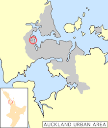 Location of Te Atatu in Auckland. | |
| Basic information | |
| Local authority | Auckland Council |
| Surrounds | |
| North | (Waitematā Harbour), Hobsonville |
| Northeast | (Waitematā Harbour), Birkdale, New Zealand, Kauri Park |
| East | (Waitematā Harbour), Point Chevalier |
| Southeast | (Whau River), Rosebank Peninsula |
| South | Glendene |
| Southwest | Henderson |
| West | Lincoln |
| Northwest | Massey |
Te Atatu (from the Maori Te Atatū: "the dawn") is the name of two suburbs in western Auckland, New Zealand: Te Atatu Peninsula and Te Atatu South. They are located next to each other some 10 kilometres to the west of the Auckland city centre.
Te Atatu Peninsula, formerly known as Te Atatu North, lies, as the name suggests, on a small peninsula. It is located at the western extremity of the Waitematā Harbour, and is formed by the Henderson Creek, an estuarial arm of the harbour that extends southwest from the harbour. The peninsula thus formed is four kilometres in length and two kilometres in width, and is joined to the main part of the North Island at its southern end.
Te Atatu South is sited at the point where the peninsula meets the rest of the island, south of the motorway interchange, which bisects the formerly more closely linked areas. Both suburban areas are characterised by a well-established suburban neighbourhood, with two town centres providing shops, medical services and community facilities. Most inhabitants work in west Auckland or Auckland City.[1]
| Electorate | Te Atatū |
|---|---|
| MP | Chris Carter (NZLP) |
The Te Atatū electorate, which covers both suburbs, was served in the New Zealand Parliament by Chris Carter, who was New Zealand's first openly gay Cabinet Minister. It is now served by Phil Twyford.
Geography
The peninsula (and to a large degree, the southern part of the suburb), is defined by Henderson Creek in the west, and the Whau River in the east. Mangroves and other estuarine epifauna dominate the boundaries, with the geology composed mostly of marine and stream sediments.[1]
History
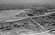
The two suburbs were relatively rural areas until the 1950s when the first stages of the Northwestern Motorway (part of State Highway 16) were opened along the coast of the Waitematā Harbour. This encouraged suburban settlements to the west of Auckland, and Te Atatu grew rapidly as a result. In the 2000s, the working-class suburb area became increasingly popular for luxury apartments and other higher-cost residential development.[3]
Proposed port
In the 1950s, there were plans to build a new deepwater port at the Te Atatu peninsula.[4] Land was acquired under public works regulations, and later, the Auckland Harbour Bridge was built to a clear height sufficient to allow large ships to pass under it. However, the port idea was never realised, and the land was later released for subdivision, though legal fights with the former landowners continue(d).[5]
Transport
The two suburbs are bisected by State Highway 16, connecting the west and northwest of Auckland to Auckland City. The Te Atatu Interchange Coordinates: 36°51.45′S 174°39.13′E / 36.85750°S 174.65217°E is being upgraded to deal with the increased traffic. The Northwestern Cycleway runs along the motorway as well, and some locals like to use it to commute to their jobs in the Auckland CBD areas.[6] Walkways and Cycleways also run along both coasts along the Henderson Creek and Whau River.
A regular bus service runs along Te Atatu Rd.
A ferry service to the city has also been proposed.[7]
Facilities
Schools
The local State secondary school is Rutherford College.[6] Other convenient State secondary schools are Henderson High School, ACG Sunderland school and college, Liston College, and St Dominic's College. Local intermediate schools are Te Atatu Intermediate and Rangeview Intermediate. There are also seven primary schools: Edmonton, Flanshaw Road, Freyberg, Tirimoana, Rutherford, Matipo and Peninsula.
Sports
Te Atatu is home to several sports clubs. Perhaps the most successful is the Te Atatu Roosters rugby league team who were national champions in 1988. They are based at Jack Colvin Park. Other teams who play in the Te Atatu area are the Te Atatu Tennis Club, Waitakere Cricket Club, Waitakere rugby union club, Waitemata Football Club, Te Atatu Football Club, West City Baseball Club, Te Atatu softball club and Te Atatu Boating Club.
References
- 1 2 Waterview Connection - Assessment of Environmental Effects: Part C. New Zealand Transport Agency. August 2010. pp. 8.6–8.8.
- ↑ Photograph taken 9 November 1951 by Whites Aviation. Photographs. Ref: WA-29674-G http://natlib.govt.nz/records/22323127
- ↑ Thompson, Wayne (2 April 2007). "Locals pay high price for high-rise". The New Zealand Herald. Retrieved 19 November 2011.
- ↑ "Harry L. Julian: City wharf vital for trade". The New Zealand Herald. 8 March 2006. Retrieved 19 November 2011.
- ↑ Judges favour owner’s descendants in latest – last? - Te Atatu port land case Archived 23 May 2010 at the Wayback Machine. - Bob Dey Property Report, 22 October 2008
- 1 2 Smith, Vaughan (6 September 2010). "My Auckland: Te Atatu Peninsula". The New Zealand Herald. Retrieved 1 October 2010.
- ↑ http://www.stuff.co.nz/auckland/local-news/7528239/Te-Atatu-ferry-could-ease-traffic