Taungup Township
| Toungup Township တောင်ကုတ်မြို့နယ် Taungup Township Taunggoke Township Taungoke Township | |
|---|---|
| Township | |
| Coordinates (the geographic center of the township): 19°0′0″N 94°22′30″E / 19.00000°N 94.37500°ECoordinates: 19°0′0″N 94°22′30″E / 19.00000°N 94.37500°E | |
| State | Rakhine State |
| District | Thandwe District |
| Population (2014)[1] | 114,437 |
| Time zone | UTC+6:30 (MST) |
Taungup or Toungup Township (Burmese: တောင်ကုတ်မြို့နယ်) is a coastal township of Thandwe District in the Rakhine State of Myanmar. The administrative centre and principal town is Toungup. The only other town is Ma-Ei.[2][3]
Principle villages include:[2]
- Kan Pyin,
- Kyauk Seik Taung,
- Let Pan Kyun,
- Maung,
- Moe Kyauk Gyi Kwin,
- Myo Taung Gyi,
- Nat Maw,
- Nga Lone Maw,
- Pa Dar,
- Sa Lu,
- Tar Ye,
- Taung,
- Thin Chi Kaing,
- Te Mauk, and
- Zee Kwin.
References
- ↑ "Rakhine Census by Township: 17. Rakhine State, Thandwe District, Taungup Township". The 2014 Myanmar Population and Housing Census: Rakhine State. Department of Population, Ministry of Labour, Immigration and Population, The Republic of the Union of Myanmar. 2015. Archived from the original on 22 April 2016.
- 1 2 Community Based ECCD Centres in Toungup Township (PDF) (Map). Myanmar Information Management Unit (MIMU). 25 February 2015. Archived (PDF) from the original on 30 August 2016.
- ↑ Ma-Ei has a sixteen bed hospital. Nay Pyi Taw (December 2015). "Annual Hospital Statistics Report 2013" (PDF). Department of Public Health, Ministry of Health. p. 138.
External links
- Toungup Township - Rakhine State (PDF) (Map). Myanmar Information Management Unit (MIMU). 3 May 2016. Archived (PDF) from the original on 8 December 2016.
Capital: Sittwe | ||
| Kyaukpyu District |  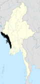 | |
| Maungdaw District | ||
| Sittwe District | ||
| Thandwe District |
| |
| Mrauk-U District | ||
| Main cities and towns | ||
This article is issued from
Wikipedia.
The text is licensed under Creative Commons - Attribution - Sharealike.
Additional terms may apply for the media files.