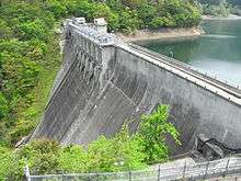
Tateiwa Dam
| Tateiwa Dam | |
|---|---|
 | |
| Location | Hiroshima Prefecture, Japan. |
| Coordinates | 34°32′40″N 132°09′50″E / 34.54444°N 132.16389°ECoordinates: 34°32′40″N 132°09′50″E / 34.54444°N 132.16389°E |
| Opening date | 1939 |
| Dam and spillways | |
| Impounds | Ōta River |
| Height | 67.4 m |
| Length | 179 m |
| Reservoir | |
| Total capacity | 17,200,000 m³ |
| Catchment area | 129.6 km² |
| Surface area | 89 hectares |
Tateiwa Dam is a dam in the Hiroshima Prefecture of Japan.
| Wikimedia Commons has media related to Dams in Hiroshima prefecture. |
This article is issued from
Wikipedia.
The text is licensed under Creative Commons - Attribution - Sharealike.
Additional terms may apply for the media files.