Targovishte Airport
| Buhovtsi/Targovishte Airport | |||||||||||
|---|---|---|---|---|---|---|---|---|---|---|---|
| Summary | |||||||||||
| Airport type | Public | ||||||||||
| Serves | Buhovtsi | ||||||||||
| Location |
| ||||||||||
| Elevation AMSL | 666 ft / 203 m | ||||||||||
| Coordinates | 43°18′24.4″N 26°42′0.4″E / 43.306778°N 26.700111°ECoordinates: 43°18′24.4″N 26°42′0.4″E / 43.306778°N 26.700111°E | ||||||||||
| Map | |||||||||||
 LBTG Location of Buhovtsi/Targovishte Airport in Bulgaria | |||||||||||
| Runways | |||||||||||
| |||||||||||
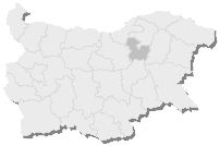
Targovishte Airport (IATA code: TGV, ICAO code: LBTG), also known Buhovtsi Airfield, is located near the village of Buhovtsi, 13 km from the city of Targovishte. Its unique location gives a chance for service of an area covering three regions including Targovishte, Shumen and Razgrad Provinces. It is currently inoperational because of the lack of financial resources.
See also
- Targovishte Province at Wikipedia
- List of airports in Bulgaria
References
- ↑ Airport record for Buhovtsi/Targovishte Airport at Landings.com. Retrieved 2013-08-22
- ↑ Google (2013-08-22). "location of Buhovtsi/Targovishte Airport" (Map). Google Maps. Google. Retrieved 2013-08-22.
External links
This article is issued from
Wikipedia.
The text is licensed under Creative Commons - Attribution - Sharealike.
Additional terms may apply for the media files.