Tantamayo District
| Tantamayo Tanta Mayu | |
|---|---|
| District | |
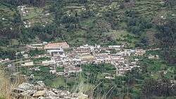 Tantamayo as seen from the archaeological sites of Phiruru | |
| Country |
|
| Region | Huánuco |
| Province | Huamalíes |
| Founded | October 29, 1923 |
| Capital | Tantamayo |
| Government | |
| • Mayor | Sofonias Heriberto Gutierrez Antonio |
| Area | |
| • Total | 249.95 km2 (96.51 sq mi) |
| Elevation | 3,495 m (11,467 ft) |
| Population (2005 census) | |
| • Total | 2,780 |
| • Density | 11/km2 (29/sq mi) |
| Time zone | UTC-5 (PET) |
| UBIGEO | 100511 |
Tantamayo (from Quechua Tanta Mayu) is one of eleven districts of the Huamalíes Province in Peru.[1]
Geography
One of the highest peaks of the district is Hatun Kancha at approximately 4,400 m (14,400 ft). Other mountains are listed below:[2]
- Chawpi Hirka
- Kiswar
- Maman Punta
- Pinqullu
- Susupillu
- Wak'a Rumi Punta
- Wiñaq
Ethnic groups
The people in the district are mainly indigenous citizens of Quechua descent. Quechua is the language which the majority of the population (72.93%) learnt to speak in childhood, 26.47% of the residents started speaking using the Spanish language (2007 Peru Census).[3]
Archaeology
Some of the most important archaeological sites of the district are Anku, Isuq, Phiruru, Susupillu and Wanqaran.
References
- ↑ (in Spanish) Instituto Nacional de Estadística e Informática. Banco de Información Distrital Archived 2008-04-23 at the Wayback Machine.. Retrieved April 11, 2008.
- ↑ escale.minedu.gob.pe/ UGEL map Huamalíes Province (Huánuco Region)
- ↑ inei.gob.pe Archived 2013-01-27 at the Wayback Machine. INEI, Peru, Censos Nacionales 2007, Frequencias: Preguntas de Población: Idioma o lengua con el que aprendió hablar (in Spanish)
| |
|---|---|
| Ambo | |
| Dos de Mayo | |
| Huacaybamba | |
| Huamalíes | |
| Huánuco | |
| Lauricocha | |
| Leoncio Prado | |
| Marañón | |
| Pachitea | |
| Puerto Inca | |
| Yarowilca | |
This article is issued from
Wikipedia.
The text is licensed under Creative Commons - Attribution - Sharealike.
Additional terms may apply for the media files.