Tann, Hesse
| Tann (Rhön) | ||
|---|---|---|
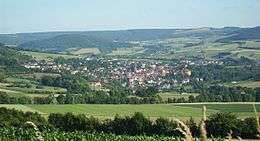 Landscape of Tann (View from northeast) | ||
| ||
 Tann (Rhön) Location of Tann (Rhön) within Fulda district _in_FD.svg.png)  | ||
| Coordinates: 50°39′N 10°01′E / 50.650°N 10.017°ECoordinates: 50°39′N 10°01′E / 50.650°N 10.017°E | ||
| Country | Germany | |
| State | Hesse | |
| Admin. region | Kassel | |
| District | Fulda | |
| Government | ||
| • Mayor | Mario Dänner (Ind.) | |
| Area | ||
| • Total | 60.45 km2 (23.34 sq mi) | |
| Elevation | 400 m (1,300 ft) | |
| Population (2017-12-31)[1] | ||
| • Total | 4,430 | |
| • Density | 73/km2 (190/sq mi) | |
| Time zone | CET/CEST (UTC+1/+2) | |
| Postal codes | 36142 | |
| Dialling codes | 06682 | |
| Vehicle registration | FD | |
| Website | www.tann-rhoen.de | |
.png)
Tann is a town in the district of Fulda, in Hesse, Germany. It is situated in the Rhön Mountains, 27 km northeast of Fulda. It is an accredited Spa town at the Ulster River.
Mayors
- Karl Hilgen (SPD) till 1983
- Wolfgang Schwake (CDU) till 1989
- Dieter Herchenhan] (SPD) till 2001
- Markus Meysner (CDU) till 2013
- Mario Dänner (independent) since 2013[2]
Buildings
 City gate of Tann (built 1557–1563)
%2C_Ev._Stadtpfarrkirche-20160505-001.jpg) Protestant church
Protestant church Tann yellow castle
 Tann blue castle
Sons and daughters of the town
- Johann Ludwig Klüber (1762-1837), state lawyer and writer
Personalities who have worked on the spot
- Johann Michael Bach (musician at Wuppertal) (1745-1820), a member of the musical Bach family. Worked in Tann as a church musician (1786 to ca. 1795)
- Sebastian Kehl (born 1980, Fulda), grew up in the district Lahrbach, professinal football player (Borussia Dortmund
References
- ↑ "Bevölkerung der hessischen Gemeinden". Hessisches Statistisches Landesamt (in German). September 2018.
- ↑ Endgültiges Wahlergebnis der Bürgermeisterwahl von 2013
Towns and municipalities in Fulda district | ||
|---|---|---|
This article is issued from
Wikipedia.
The text is licensed under Creative Commons - Attribution - Sharealike.
Additional terms may apply for the media files.