Tamgaly
| UNESCO World Heritage site | |
|---|---|
 Petroglyphs of Tamgaly | |
| Location | Kazakhstan |
| Criteria | Cultural: (iii) |
| Reference | 1145 |
| Inscription | 2004 (28th Session) |
| Area | 900 ha (2,200 acres) |
| Buffer zone | 2,900 ha (7,200 acres) |
| Coordinates | 43°48′12″N 75°32′6″E / 43.80333°N 75.53500°ECoordinates: 43°48′12″N 75°32′6″E / 43.80333°N 75.53500°E |
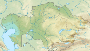 Location of Tamgaly in Kazakhstan | |
Tamgaly is a petroglyph site in the Zhetysu of Kazakhstan. Tamgaly became a UNESCO World Heritage Site in 2004. Tamgaly is located 170 km (by road) northwest of Almaty.
Description
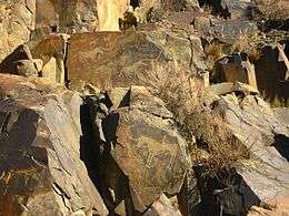
The majority of the 5000 petroglyphs are in the main canyon, but there are a number in the many side canyons. The petrogylphs are mostly Bronze Age, but in some cases have been overlaid with Medieval or later etchings. There are some petrogylphs from the Iron Age.[1]
The name Tamgaly in Kazakh and other Turkic languages means "painted or marked place".
See also
Gallery
 Ancient stone carvings (petroglyphs) found in a small ravine at Tamgaly
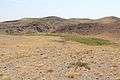 Looking across the small ravine that contains the petroglyphs
 Petroglyphs of ancient tribal dance and animals
 The largest group of petroglyphs in a sacred site
 Petroglyphs in Tamgaly, Unesco World Heritage Site, Kazakhstan
 Petroglyphs in Tamgaly, Unesco World Heritage Site, Kazakhstan
 Petroglyphs in Tamgaly
 view of landscape Tamgaly
References
External links
| Wikimedia Commons has media related to Tamgaly. |
- "Petroglyphs within the Archaeological Landscape of Tamgaly" UNESCO
- Goryachev, A. A. and Mariyashev, A. N. (2000) "Petrogliphs of Semirechye"; [Access to this URL no longer possible]
- "Semirechye Petroglifleri", in Turkish, from WebArchive;
This article is issued from
Wikipedia.
The text is licensed under Creative Commons - Attribution - Sharealike.
Additional terms may apply for the media files.