Talensi-Nabdam District
| Talensi-Nabdam District | |
|---|---|
| District | |
 Districts of Upper East region | |
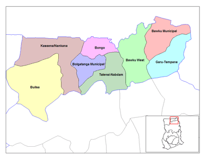
 Talensi-Nabdam District Talensi-Nabdam in Upper East region | |
| Coordinates: 10°43′N 0°48′W / 10.717°N 0.800°W | |
| Region | Upper East Region |
| Capital | Tongo |
| Government | |
| • District Executive | Sebastian T. Bisnab |
| Area | |
| • Total | 912 km2 (352 sq mi) |
| Population (2013) | |
| • Total | — |
| Time zone | UTC+0 (GMT) |
| ISO 3166 code | GH-UE-TN |
The Talensi-Nabdam District is one of the nine (9) districts in the Upper East Region of north Ghana. The capital is Tongo.
Background
Talensi-Nabdam, one of the newly created districts was carved from the Bolgatanga District with Tongo as its capital. It has a population of about 94650, bordered to the North by the Bolgatanga District, South by the West and East Mamprusi Districts, Kassena-Nanakana District to the West and the Bawku West District to the East. The district lies between latitude 10.15° and 10.60° north of the equator and longitude 0.31° and 10.50.[1]
Physical and Natural Environment
Topography and Drainage
The district has gentle slopes ranging from 1% to 5% gradient with some isolated rocks while some upland slopes range around 10% at the Tongo and Nangodi areas. The district is drained mainly by the Red and White Volta and their tributaries.
Geology and Soil
The rocks fall within the Birimian, Tarkwaian and Voltaria types of Ghana. There is evidence of presence of minerals especially gold.
Climate
The climate is tropical with two distinct seasons, the Wet (rainy) and Dry (no rain). The rainy season is erratic, and runs from May to October each year with an annual mean of 950mm. The dry season is long and stretches from October to April. Temperatures can be with a maximum of 450 C in March and April with a minimum of 120C in December.
Vegetation
The vegetation is guinea savannah woodland consisting of short widely spread deciduous trees and a ground flora of grass, which get burnt by fire or sun scorch during the long dry season. The most common economic trees are the Shea nuts, dawadawa, baobab and acacia.
The district has three gazetted forest reserves covering a total area of 455.21 sq km; Nyokoko (established in 1954), Tankwiddi East and The Red Volta were respectively established in 1956.
Environmental Situation
The natural environment is fairly degraded as it faces threat of severe drought with high temperatures and perennial outbreak of bush fires. It is evident that high population densities (especially in towns) with high demand for land for constructional activities, extensive cultivation, over-grazing, erratic rainfall and the extent of devastation do affect the natural environment thereby exposing it to desertification. Illegal surface mining is a major threat to the environment by degrading land and pollution of water bodies.
Water Supply
Access to portable water is indeed a problem and the District Assembly and other development partner are working to collectively find a solution. Small Town Water System (STWS) have provided boreholes and hand-dug wells for many communities in the district with support from NGOs (ADRA, Rural Aid and WorldVision Ghana).
Labour Force
The labour force in the district comprises agricultural labour, non-agricultural labour and casual labour. Under agricultural labour, family labour claims over 60% usually comprising men, women and children of age 15 years at least. The remaining 40% goes to non-agricultural labour and casual labour. The demand for labour is at its peak in the rainy season, when more farming activities are being carried out.
Agriculture (Husbandry)
The District Agricultural Development Unit is geared towards ensuring food security all year round in collaboration with other development partners. Agriculture plays important roles in the socio-economic development of the Talensi-Nabdam District, aside food security; it provides employment and incomes for over 90% the population. The district has arable land area of 56% (49,200 ha) and 9,000 farm households with an average land holding of 1.2ha per household which falls below the National Average of 4ha. About 90% of its population is peasant farmers who grow mostly food crops.
Crops
The main crops cultivated by farmers during the rainy season are:
- Cereals: millet, sorghum, rice, maize
- Legumes: groundnuts, cowpea, soybean, bambara beans
- Vegetables: tomato, pepper, okro, garden eggs,
- Tubers: Sweet Potato, frafra potato.
Livestock
Apart from crop production, livestock and poultry rearing is the second most important feature in agricultural development. Almost all farmers are engaged in the rearing of at least one type of livestock and poultry. Livestock serves as a good source of income for farmers especially when there is crop failure. Production is largely at the subsistence level. The livestock reared include poultry (guinea fowls, fowls, ducks, and turkeys), cattle, sheep, goats, pigs and donkeys.
Sources
- "Districts of Ghana". Statoids.
References
- ↑ "Talensi-Nabdam". Ministry of Food & Agriculture. 2011-07-06. Retrieved 2017-11-27.
| Municipal |
| .svg.png) |
|---|---|---|
| District |
| |