Taketa, Ōita
| Taketa 竹田市 | |||
|---|---|---|---|
| City | |||
 | |||
| |||
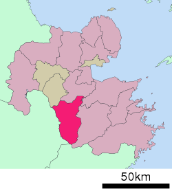 Location of Taketa in Ōita Prefecture | |||
 Taketa Location in Japan | |||
| Coordinates: 32°58′N 131°24′E / 32.967°N 131.400°ECoordinates: 32°58′N 131°24′E / 32.967°N 131.400°E | |||
| Country | Japan | ||
| Region | Kyushu | ||
| Prefecture | Ōita Prefecture | ||
| Government | |||
| • Mayor | Katsuji Syuto (since April 2009) | ||
| Area | |||
| • Total | 477.59 km2 (184.40 sq mi) | ||
| Population (March 31, 2017) | |||
| • Total | 22,661 | ||
| • Density | 47/km2 (120/sq mi) | ||
| Symbols | |||
| • Tree | Maple Leaf | ||
| • Flower | Miyama Kirishima | ||
| • Bird | Cettia diphone | ||
| Time zone | UTC+9 (JST) | ||
| City hall address |
Oji-Aiai 1650, Taketa City, Oita Prefecture (大分県竹田市大字会々1650番地) 878-8555 | ||
| Website |
www | ||


Taketa (竹田市 Taketa-shi) is a city located in Ōita Prefecture, Japan. The city was founded on March 31, 1954. On April 1, 2005, the towns of Kujū, Naoiri and Ogi (all from Naoiri District) were also merged into Taketa.
As of March 31, 2017, the city has an estimated population of 22,661, with 10,393 households and a population density of 47 persons per km².[1] The total area is 477.59 km².
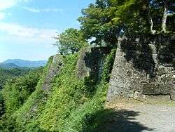
Oka Castle is a famous local historic site.
Notable people from Taketa
- Iwao Akiyama, former woodblock printmaker
- Korechika Anami, former general in the Imperial Japanese Army during World War II
- Kenji Anan, stage and film actor
- Takeo Hirose, former career officer in the Imperial Japanese Navy
- Otoya Kawano, voice actor
References
- ↑ "Official website of Taketa city" (in Japanese). Japan: Taketa City. Retrieved 19 April 2017.
External links

- Official website (in Japanese)
| Core city | ||
|---|---|---|
| Cities | ||
| Districts | ||
This article is issued from
Wikipedia.
The text is licensed under Creative Commons - Attribution - Sharealike.
Additional terms may apply for the media files.