Taymyrsky Dolgano-Nenetsky District
Coordinates: 72°00′N 95°00′E / 72.000°N 95.000°E
| Taymyrsky Dolgano-Nenetsky District Таймырский Долгано-Ненецкий район (Russian) | |
|---|---|
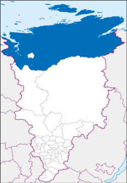 Location of Taymyrsky Dolgano-Nenetsky District in Krasnoyarsk Krai | |
.jpg) Landscape with rainstorm, Taymyrsky Dolgano-Nenetsky District | |
 |
 |
|
| |
| Location | |
| Country | Russia |
| Federal subject | Krasnoyarsk Krai[1] |
| Administrative structure (as of December 2011) | |
| Administrative center | town of Dudinka[1] |
| Administrative divisions:[1] | |
| District towns | 1 |
| Urban-type settlements | 1 |
| Selsoviets | 2 |
| Inhabited localities:[1] | |
| Cities/towns | 1 |
| Urban-type settlements[2] | 1 |
| Rural localities | 25 |
| Municipal structure (as of February 2012) | |
| Municipally incorporated as | Taymyrsky Dolgano-Nenetsky Municipal District[3] |
| Municipal divisions:[3] | |
| Urban settlements | 2 |
| Rural settlements | 2 |
| Local government: | |
| Head[4] | Sergey V. Baturin[5] |
| Representative body | Duma[6] |
| Statistics | |
| Area (municipal district) | 897,900 km2 (346,700 sq mi)[5] |
| Population (2010 Census) | 34,432 inhabitants[7] |
| • Urban | 66.4% |
| • Rural | 33.6% |
| Density | 0.04/km2 (0.10/sq mi)[8] |
| Time zone | KRAT (UTC+07:00)[9] |
| Established | April 10, 1930[5] |
| Official website | |
| Taymyrsky Dolgano-Nenetsky District on WikiCommons | |
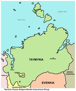
Taymyrsky Dolgano-Nenetsky District (Russian: Таймы́рский Долга́но-Не́нецкий райо́н) is an administrative[1] and municipal[3] district (raion), one of the forty-three in Krasnoyarsk Krai, Russia. It is located in the north of the krai above the Arctic Circle on the Taymyr Peninsula and borders with Laptev and Kara Seas in the north, the Sakha Republic in the east, Evenkiysky and Turukhansky Districts in the south, and with Yamalo-Nenets Autonomous Okrug in the west. The area of the district is 879,900 square kilometers (339,700 sq mi).[5] Its administrative center is the town of Dudinka.[1] Population: 34,432 (2010 Census);[7] 39,786 (2002 Census);[10] 55,111 (1989 Census).[11] The population of Dudinka accounts for 64.4% of the district's total population.[7]
Since one can only arrive by either air or sea, Norilsk is often thought of as an island entirely surrounded by the Taymyrsky Dolgano-Nenetsky District. However, it is not under the administration of Taymyrsky Dolgano-Nenetsky District. In 2005, the central city of Norilsk merged with its satellite cities or neighborhoods (Talnakh and Kayerkan) as a municipal division. Greater Norilsk, or Big Norilsk (Russian: «Большой Норильск» ), is the Norilsk Industrial Region (Russian: Нори́льский промы́шленный райо́н, (НПР)) and is the Krai city of Norilsk. Greater Norilsk includes Norilsk, the remote area (Russian: отдалённый район) of Oganer, and the urban-type settlement of Snezhnogorsk and is equal to a district within the Krasnoyarsk Krai and is not part of the Taymyrsky Dolgano-Nenetsky District.[12][13]
History
The district was founded on April 10, 1930.[5] Until January 1, 2007, it existed as Taymyr Autonomous Okrug, a federal subject of Russia.
Government
As of 2013, the Head of the district and the Chairman of the District Duma is Sergey V. Baturin.[5]
Demographics
Vital statistics
| Average population (x 1000) | Live births | Deaths | Natural change | Crude birth rate (per 1000) | Crude death rate (per 1000) | Natural change (per 1000) | |
|---|---|---|---|---|---|---|---|
| 2007 | 37 | 592 | 335 | 257 | 16.2 | 9.2 | 7.0 |
| 2008 | 36 | 586 | 360 | 226 | 16.3 | 10.0 | 6.3 |
| 2009 | 35 | 611 | 387 | 224 | 17.3 | 11.0 | 6.4 |
| 2010 | 35 | 602 | 351 | 251 | 17.4 | 10.1 | 7.3 |
References
Notes
- 1 2 3 4 5 6 Law #10-4765
- ↑ The count of urban-type settlements may include the work settlements, the resort settlements, the suburban (dacha) settlements, as well as urban-type settlements proper.
- 1 2 3 Law #2-54
- ↑ Charter of Taymyrsky Dolgano-Nenetsky District, Article 20.1
- 1 2 3 4 5 6 Official website of Krasnoyarsk Krai. Information about Taymyrsky Dolgano-Nenetsky District (in Russian)
- ↑ Charter of Taymyrsky Dolgano-Nenetsky District, Article 20.2
- 1 2 3 Russian Federal State Statistics Service (2011). "Всероссийская перепись населения 2010 года. Том 1" [2010 All-Russian Population Census, vol. 1]. Всероссийская перепись населения 2010 года (2010 All-Russia Population Census) (in Russian). Federal State Statistics Service. Retrieved June 29, 2012.
- ↑ The value of density was calculated automatically by dividing the 2010 Census population by the area specified in the infobox. Please note that this value is only approximate as the area specified in the infobox does not necessarily correspond to the area of the entity proper or is reported for the same year as the population.
- ↑ Правительство Российской Федерации. Федеральный закон №107-ФЗ от 3 июня 2011 г. «Об исчислении времени», в ред. Федерального закона №271-ФЗ от 03 июля 2016 г. «О внесении изменений в Федеральный закон "Об исчислении времени"». Вступил в силу по истечении шестидесяти дней после дня официального опубликования (6 августа 2011 г.). Опубликован: "Российская газета", №120, 6 июня 2011 г. (Government of the Russian Federation. Federal Law #107-FZ of June 31, 2011 On Calculating Time, as amended by the Federal Law #271-FZ of July 03, 2016 On Amending Federal Law "On Calculating Time". Effective as of after sixty days following the day of the official publication.).
- ↑ Russian Federal State Statistics Service (May 21, 2004). "Численность населения России, субъектов Российской Федерации в составе федеральных округов, районов, городских поселений, сельских населённых пунктов – районных центров и сельских населённых пунктов с населением 3 тысячи и более человек" [Population of Russia, Its Federal Districts, Federal Subjects, Districts, Urban Localities, Rural Localities—Administrative Centers, and Rural Localities with Population of Over 3,000] (XLS). Всероссийская перепись населения 2002 года [All-Russia Population Census of 2002] (in Russian). Retrieved August 9, 2014.
- ↑ Demoscope Weekly (1989). "Всесоюзная перепись населения 1989 г. Численность наличного населения союзных и автономных республик, автономных областей и округов, краёв, областей, районов, городских поселений и сёл-райцентров" [All Union Population Census of 1989: Present Population of Union and Autonomous Republics, Autonomous Oblasts and Okrugs, Krais, Oblasts, Districts, Urban Settlements, and Villages Serving as District Administrative Centers]. Всесоюзная перепись населения 1989 года [All-Union Population Census of 1989] (in Russian). Институт демографии Национального исследовательского университета: Высшая школа экономики [Institute of Demography at the National Research University: Higher School of Economics]. Retrieved August 9, 2014.
- ↑ "Официальный сайт города Норильск: Территориальные управления" [Official website city of Norilsk: Territorial management]. www.norilsk-city.ru (in Russian). Retrieved November 16, 2016.
- ↑ "Норильск: Генеральный план городского округа" [Norilsk: General map of municipal region]. www.norilsk-city.ru (in Russian). Retrieved November 16, 2016.
Sources
- Законодательное собрание Красноярского края. Закон №10-4765 от 10 июня 2010 г. «О перечне административно-территориальных единиц и территориальных единиц Красноярского края», в ред. Закона №7-3007 от 16 декабря 2014 г. «Об изменении административно-территориального устройства Большеулуйского района и о внесении изменений в Закон края "О перечне административно-территориальных единиц и территориальных единиц Красноярского края"». Вступил в силу 1 июля 2010 г. Опубликован: "Ведомости высших органов государственной власти Красноярского края", №33(404), 5 июля 2010 г. (Legislative Assembly of Krasnoyarsk Krai. Law #10-4765 of June 10, 2010 On the Registry of the Administrative-Territorial Units and the Territorial Units of Krasnoyarsk Krai, as amended by the Law #7-3007 of December 16, 2014 On Changing the Administrative-Territorial Structure of Bolsheuluysky District and on Amending the Krai Law "On the Registry of the Administrative-Territorial Units and the Territorial Units of Krasnoyarsk Krai". Effective as of July 1, 2010.).
- Законодательное собрание Красноярского края. Закон №2-54 от 9 февраля 2012 г. «Об установлении границ муниципального образования Таймырский Долгано-Ненецкий муниципальный район и находящихся в его границах иных муниципальных образований», в ред. Закона №5-1826 от 21 ноября 2013 г. «О внесении изменений в Законы края об установлении границ и наделении соответствующим статусом муниципальных образований Красноярского края». Вступил в силу через десять дней со дня официального опубликования. Опубликован: "Ведомости высших органов государственной власти Красноярского края", №8(520)/1 и №8(520)/2, 6 марта 2012 г. (Legislative Assembly of Krasnoyarsk Krai. Law #2-54 of February 9, 2012 On Establishing the Borders of the Municipal Formation of Taymyrsky Dolgano-Nenetsky Municipal District and of Other Municipal Formations Within Its Borders, as amended by the Law #5-1826 of November 21, 2013 On Amending the Krai Laws on Establishing the Borders and Granting an Appropriate Status to the Municipal Formations of Krasnoyarsk Krai. Effective as of the day which is ten days from the day of the official publication.).
- Собрание Таймырского Долгано-Ненецкого муниципального района. Решение №02-0063 от 22 декабря 2005 г. «О принятии Устава Таймырского Долгано-Ненецкого муниципального района», в ред. Решения №03-0039 от 14 апреля 2009 г «О внесении изменений в Устав Таймырского Долгано-Ненецкого муниципального района». Вступил в силу со дня официального опубликования, но не ранее 1 января 2006 года, за исключением положений, для которых пунктами 2 и 3 статьи 90 установлены иные сроки вступления в силу. Опубликован: "Таймыр", №155, 30 декабря 2005 г. (Assembly of Taymyrsky Dolgano-Nenetsky Municipal District. Decision #02-0063 of December 22, 2005 On the Adoption of the Charter of Taymyrsky Dolgano-Nenetsky Municipal District, as amended by the Decision #03-0039 of April 14, 2009 On Amending the Charter of Taymyrsky Dolgano-Nenetsky Municipal District. Effective as of the day of the official publication, but not earlier than January 1, 2006, with the exception of the clauses for which items 2 and 3 of Article 90 establish different dates of taking effect.).