Taghdumbash Pamir
| Taghdumbash Pamir | |
|---|---|
 | |
| Geography | |
| Location | Taxkorgan, Xinjiang, China |
| Population centers | Tashkurgan & Dafdar |
| Coordinates | 37°12′N 75°24′E / 37.200°N 75.400°ECoordinates: 37°12′N 75°24′E / 37.200°N 75.400°E |
| Traversed by | Karakoram Highway |
| Taghdumbash Pamir | |||||||
| Traditional Chinese | 塔克敦巴什帕米爾 | ||||||
|---|---|---|---|---|---|---|---|
| Simplified Chinese | 塔克敦巴什帕米尔 | ||||||
| |||||||
| Alternative Chinese name | |||||||
| Traditional Chinese | 塔德八士 | ||||||
| |||||||
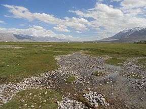
Taghdumbash Pamir (Chinese: 塔克敦巴什帕米尔 or Chinese: 塔德八士) or Taxkorgan Valley[1] is a pamir or high valley[2] in the south west of Tashkurgan Tajik Autonomous County, in Xinjiang, China. It lies to the west of the Karakoram Highway. It is inhabited by Wakhi, Kirghiz and Tajik animal herders, who graze yaks and other animals on the grasslands of the pamir.[3]
The name Taghdumbash Pamir is also sometimes applied to the mountain ranges surrounding the pamir, on the borders of Pakistan, Afghanistan, and Tajikistan, straddling the Pamir Mountains along the Sarikol Range, the Hindu Kush, the Mustagh mountains, and the Wakhan. The range divides Badakhshan Province in Afghanistan, Gorno-Badakhshan Autonomous Province in Tajikistan, and Gilgit-Baltistan in Pakistan.
During the Qing Dynasty the Chinese claimed suzerainty over the Taghdumbash Pamir but permitted the Mir of Hunza to administer the region in return for a tribute. Until 1937 the inhabitants paid tribute to the Mir of Hunza, who exercised control over the pastures.[3]
In 1984, the pamir and surrounding area was designated Taxkorgan Nature Reserve.[1] Chalachigu Valley, an offshoot of the pamir is the only place in China where Marco Polo sheep can be found.[4]
References
- 1 2 "Taxkorgan Nature Reserve". icimod.org. International Centre for Integrated Mountain Development. Retrieved 2017-02-05.
Basically flat and in places more than 5km wide, the Taxkorgan Valley (the Taghdumbash Pamir on old maps) was part of the ancient Silk Route
- ↑ Stein, M. Aurel (1907). Ancient Khotan: Detailed Report of Archaeological Explorations in Chinese Turkestan. vol. 1. Oxford, UK: Clarendon Press. p. 32.
That part of the valley which properly bears the designation of Taghdumbash Pamir may be said to extend from the Wakhjir Pass to a short distance above Dafdar
- 1 2 Wiener, Gerald (June 2003). "Yak keeping in Western High Asia: Tajikistan, Afghanistan, Southern Xinjiang Pakistan, by Hermann Kreutzmann". The Yak (2nd ed.). Bangkok: FAO RAP. ISBN 9251049653.
- ↑ USFWS (1990-10-05). "Endangered and Threatened Wildlife and Plants; Proposed Threatened Status for Argali" (PDF). Federal Register. USDOI. Retrieved 2017-02-05.
consisting of fewer than 150 animals, was confined to the western part of the Chalachigu Valley, a finger of land extending between Afghanistan on the north and Pakistan to the south.
External links
