Taastrup
| Taastrup | |
|---|---|
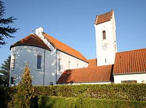
 Taastrup New Church in September 2006 | |
|
| |
 Taastrup | |
| Coordinates: 55°39′04″N 12°15′58″E / 55.65111°N 12.26611°E | |
| Country | Denmark |
| Region | Capital (Hovedstaden) |
| Municipality | Høje-Taastrup |
| Government | |
| • Mayor | Michael Ziegler |
| Area(in Høje-Taastrup Municipality) | |
| • City | 78.41 km2 (30.27 sq mi) |
| Elevation | 28 m (92 ft) |
| Population (2014) | |
| • City | 33,121 |
| • Density | 420/km2 (1,100/sq mi) |
| • Metro | 48,807 |
| Time zone | UTC+1 (CET) |
| • Summer (DST) | UTC+2 (CEST) |
| Postal code | 2630 |
| Area code(s) | (+45) 43 |
| Website | http://www.htk.dk/ |
Taastrup is a Danish railway town or/and suburb of Copenhagen - 15 km west of the capital's city centre, and formerly the administrative seat of Høje-Taastrup Municipality, Region Hovedstaden. It takes its name from the village of Taastrup Valby, which also gave its name to the station established in 1859, from which the town grew. The population on 1 January 2014 was 33,121.[1] It forms a twin (sub)urban area with neighbouring suburb Høje Taastrup since the 1980s, that has engulfed the villages of Taastrup Valby, Høje Taastrup, Kragehave and Klovtofte. This area has almost grown together with the town of Hedehusene.
Geography
The town is halfway between Metropolitan Copenhagen and Roskilde, close to the suburbs and municipalities of Albertslund and Ishøj.
Twinned cities
See also
- Høje-Taastrup Municipality
- Høje-Taastrup Station
- Taastrup Station
- Taastrup Water Tower
- Treaty of Taastrup
- Danish Technological Institute
References
- ↑ BEF44: Population 1.January by urban areas database from Statistics Denmark
External links
![]()