Cetatea de Baltă
| Cetatea de Baltă | |
|---|---|
| Commune | |
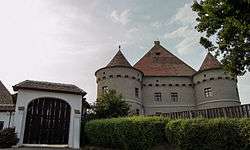 Bethlen-Haller Castle | |
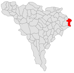 Location in Alba County | |
 Cetatea de Baltă Location in Romania | |
| Coordinates: 46°15′N 24°10′E / 46.250°N 24.167°E | |
| Country |
|
| County | Alba County |
| Population (2011)[1] | |
| • Total | 2,798 |
| Time zone | UTC+2 (EET) |
| • Summer (DST) | UTC+3 (EEST) |
Cetatea de Baltă (Hungarian: Küküllővár; German: Kokelburg) is a commune in Alba County, Romania. It is located between Târnăveni at 15 kilometers and Blaj at 21 kilometers on the county road DJ 117. The commune is composed of four villages: Cetatea de Baltă, Crăciunelu de Sus (Christendorf; Felsőkarácsonyfalva), Sântămărie (Frauenkirch; Boldogfalva) and Tătârlaua (Taterloch; Felsőtatárlaka).
Population
At the 2011 census, the commune had 2798 inhabitants, of whom 48.4% were Romanians, 33.3% Roma, 17.8% Hungarians and 0.5% Germans.
The villages by ethnic majority, as of 2002:
| In Romanian | In Hungarian | Ethnic majority |
|---|---|---|
| Cetatea de Baltă | Küküllővár | Romanians |
| Crăciunelu de Sus | Felsőkarácsonfalva | Romanians |
| Săntămărie | Boldogfalva | Hungarians |
| Tătârlaua | Felsőtatárlaka | Roma |
Touristic sights
- The Bethlen Castle, built in the 16th century in the French Renaissance style and restored in the 17th-18th centuries in the Baroque style.
- A fortress (1st century BC-1st century AD), today only ruins.
- The Reformed Church, a 13th-century building.
Economy
The most important economic resource is agriculture. Cetatea de Baltă is part of the Târnave Vineyard, making viticulture an essential component of the local economy.
References
- ↑ "Comunicat de presă privind rezultatele provizorii ale Recensământului Populaţiei şi Locuinţelor – 2011" (PDF) (in Romanian). INSSE. February 2, 2012. Archived from the original (PDF) on April 18, 2013. Retrieved 2012-03-26.
| Wikimedia Commons has media related to Cetatea de Baltă. |

This article is issued from
Wikipedia.
The text is licensed under Creative Commons - Attribution - Sharealike.
Additional terms may apply for the media files.