Târnava Mare
| Râul Târnava Mare | |
| Nagy-Küküllő, Große Kokel | |
| River | |
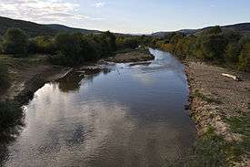 The Târnava Mare River near Blaj | |
| Countries | Romania |
|---|---|
| Counties | Harghita, Mureș, Sibiu, Alba |
| Tributaries | |
| - left | Șaeș, Vișa |
| - right | Feernic |
| Towns | Odorheiu Secuiesc, Sighișoara, Mediaș, Blaj |
| Source | |
| - location | Gurghiu Mountains |
| - elevation | 1,455 m (4,774 ft) |
| Mouth | Târnava River |
| - location | Blaj |
| - coordinates | 46°10′16″N 23°53′31″E / 46.17111°N 23.89194°ECoordinates: 46°10′16″N 23°53′31″E / 46.17111°N 23.89194°E |
| Length | 223 km (139 mi) |
| Basin | 3,666 km2 (1,415 sq mi) |
| Discharge | for * |
| - average | 14.5 m3/s (512 cu ft/s) |
| Progression | Târnava→ Mureș→ Tisza→ Danube→ Black Sea |
The Târnava Mare River ("Big Târnava"; Hungarian: Nagy-Küküllő; German: Große Kokel) is a river in Romania. Its total length is 223 km, and its drainage basin area is 3,666 km2.[1] Its source is in the Eastern Carpathian Mountains, near the sources of the Mureș and Olt in Harghita County. It flows through the Romanian counties of Harghita, Mureș, Sibiu, and Alba. The cities of Odorheiu Secuiesc, Sighișoara, and Mediaș lie on the Târnava Mare. It joins the Târnava Mică in Blaj, forming the Târnava.
Towns and villages
The following towns and villages are situated along the river Târnava Mare, from source to mouth: Subcetate, Zetea, Brădești, Odorheiu Secuiesc, Feliceni, Mugeni, Porumbeni, Cristuru Secuiesc, Secuieni, Sighișoara, Daneș, Dumbrăveni, Dârlos, Mediaș, Copșa Mică, Micăsasa, Valea Lungă, Blaj.
Tributaries
The following rivers are tributaries to the river Târnava Mare:
Left: Chiuveș, Vărșag, Șicasău, Izvoare, Deșag, Fembediu, Garon, Hodoș, Pârâul Mare, Var, Filiaș, Scroafa, Daia, Șapartoc, Herteș, Valea Dracului, Pârâul Câinelui, Șaeș, Criș, Laslea, Valchid, Biertan, Hodoș, Aţel, Valea Mare, Buzd, Moșna, Ighiș, Râul Târgului, Vorumloc, Vișa, Soroștin, Cenade, Spătac, Veza
Right: Tartod, Creanga Mică, Senced, Tifan, Bosnyak, Pârâul Sărat, Fehéres, Cireșeni, Beta, Râul Tăieturii, Pârâul Tulbure, Fâneaţa Îngustă, Feernic, Goagiu, Pârâul Stânei, Eliseni, Hetiur, Ernea, Giacăș, Șmig, Curciu, Păucea, Valea Lungă
Târnava Mare SCI
The dry grassland habitat beside the river is now part of a (SCI) Site of Community Importance.[2]
References
- ↑ 2017 Romanian Statistical Yearbook, p. 13
- ↑ Šeffer, Jan (15 December 2013). "CONSERVATION ACTION PLAN" (PDF). fundatia-adept.org. Retrieved 29 August 2015.
Maps
External links
| Wikimedia Commons has media related to Târnava Mare. |