Szprotawa
| Szprotawa | ||
|---|---|---|
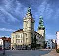 Szprotawa town hall | ||
| ||
 Szprotawa | ||
| Coordinates: 51°34′N 15°30′E / 51.567°N 15.500°E | ||
| Country |
| |
| Voivodeship | Lubusz | |
| County | Żagań | |
| Gmina | Szprotawa | |
| Government | ||
| • Mayor | Józef Rubacha | |
| Area | ||
| • Total | 10.94 km2 (4.22 sq mi) | |
| Population (2006) | ||
| • Total | 12,613 | |
| • Density | 1,200/km2 (3,000/sq mi) | |
| Time zone | UTC+1 (CET) | |
| • Summer (DST) | UTC+2 (CEST) | |
| Postal code | 67-300 | |
| Car plates | FZG | |
| Website | http://www.szprotawa.pl | |
Szprotawa [ʂprɔˈtava] (German: Sprottau) is a town in Poland, in Lubusz Voivodeship, in Żagań County. It has 12,648 inhabitants (2004).
History
The first information about the terrains of today's Szprotawa comes at 1000 from the chronicle of bishop Thietmar of Merseburg, who accompanied the emperor Otto III on pilgrimage to the grave of holy Adalbert in Gniezno. Until World War II the town was part of Germany.
Sights to see
- Old city
- Sagan Gate, from the Middle Ages
- Town hall, from the Renaissance
- Saint Andreas Roman Catholic Church, from the 13th century
- Saint Mary's Roman Catholic Church, from the 13th century
- Evangelical Church, from the 18th century (old castle)
- Old military airport with nuclear weapons storage
- Castle Chrobry (archeological)
- Silesia Walls
Nature
- Oak "Chrobry", the oldest in Poland (750 years old)
- Naturreserve "Buczyna Szprotawska"
- Naturreserve "Park Słowiański"
- Lower Silesia Forest
- Old city park from the 19th century
Notable residents
- Jakob Ebert (1549–1614), theologian
- Heinrich Göppert (1800–1884), scientist
- Heinrich Laube (1806–1884), author
- Karl Bartsch (1832–1888), Germanist
- Robert Beisert (1833–1893), politician
- Harald Bielfeld (1863–1933), politician
- Walter Dötsch (1909–1987), artist
- Hans-Joachim Höfig (1915–2006), Sportsman
- Manfred Steinbach (born 1933), sportsman
- Roswitha Berndt (born 1936), historian
- Klaus Hänsch (born 1938), politician, President of the European Parliament
- Rudolf Langer (bon 1939), sportsman
- Detlev Kittstein (1944–1996), sportsman
- Fritz Puppel (born 1944), musician
International relations
Twin towns — Sister cities
Szprotawa is twinned with:
See also
Gallery
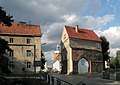 The museum (Sagan Gate)
- City Center
 Center City Park
 West Tower
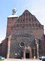 Saint Mary`s Church
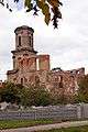 Ruin of Evangelical Church (old castle)
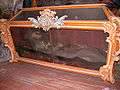 Saint Faustina sarcophagus
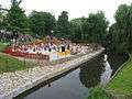
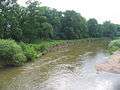 Bóbr River by Slavic Park
External links
- Official town webpage
- Official museum webpage
- Jewish Community in Szprotawa on Virtual Shtetl
| Wikimedia Commons has media related to Szprotawa. |
References
- Notes
- ↑ "List of Twin Towns in the Ruhr District" (PDF). © 2009 Twins2010.com. Archived from the original (PDF) on 2009-11-28. Retrieved 2009-10-28. External link in
|publisher=(help)
| Town and seat |  | |
|---|---|---|
| Villages | ||
This article is issued from
Wikipedia.
The text is licensed under Creative Commons - Attribution - Sharealike.
Additional terms may apply for the media files.