Swinstead
| Swinstead | |
|---|---|
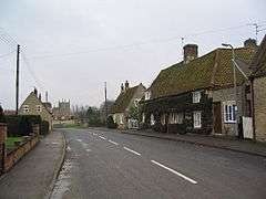 Swinstead village | |
 Swinstead Swinstead shown within Lincolnshire | |
| Population | 234 (2011) |
| OS grid reference | TF017224 |
| • London | 90 mi (140 km) S |
| District | |
| Shire county | |
| Region | |
| Country | England |
| Sovereign state | United Kingdom |
| Post town | GRANTHAM |
| Postcode district | NG33 |
| Police | Lincolnshire |
| Fire | Lincolnshire |
| Ambulance | East Midlands |
| EU Parliament | East Midlands |
| UK Parliament | |
Swinstead is a village and civil parish in the South Kesteven district of Lincolnshire, England. It is situated 5 miles (8.0 km) west from Bourne, 9 miles (14.5 km) north from Stamford and 11 miles (17.7 km) south-east from Grantham. It is a village of just over 100 households, the population of the civil parish being measured at 234 in the 2011 census.[1]
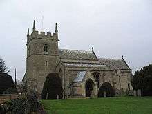
St Mary's church, Swinstead
Swinstead parish church is dedicated to St Mary. The village has a public house, but the nearest amenities are 2 miles (3.2 km) away at Corby Glen. Adjacent villages include Creeton, Swayfield and Grimsthorpe.
References
- ↑ "Civil Parish population 2011". Neighbourhood Statistics. Office for National Statistics. Retrieved 1 June 2016.
External links

- Historic England. "Tower Farm (520867)". PastScape. (alternatively Swinstead Old Hall), a 19th-century farm and farm buildings, to the west on the Grimsthorpe Estate.
- Bourne & Heckington (Map) (3 ed.). 1:25000. OS Explorer Map. OSGB. 2006. § 248. ISBN 978-0-319-23811-0. Retrieved 14 March 2010.
- "Swinstead", Genuki.org.uk. Retrieved 11 May 2012
- Swinstead – aerial view
England Portal | |
| Unitary authorities | |
| Boroughs or districts | |
| Major settlements |
|
| Topics | |
This article is issued from
Wikipedia.
The text is licensed under Creative Commons - Attribution - Sharealike.
Additional terms may apply for the media files.