Swinney Switch, Texas
| Swinney Switch, Texas | |
|---|---|
| Unincorporated community | |
 Swinney Switch, Texas Location within the state of Texas  Swinney Switch, Texas Swinney Switch, Texas (the US) | |
| Coordinates: 28°14′41″N 97°55′13″W / 28.24472°N 97.92028°WCoordinates: 28°14′41″N 97°55′13″W / 28.24472°N 97.92028°W | |
| Country | United States |
| State | Texas |
| County | Live Oak |
| Elevation | 210 ft (60 m) |
| Time zone | UTC-6 (Central (CST)) |
| • Summer (DST) | UTC-5 (CDT) |
| ZIP codes | 78368 |
| GNIS feature ID | 1348156 |
Swinney Switch, also known as Swinney, is an unincorporated community in southeastern Live Oak County, Texas, United States. It lies approximately 12 miles (19 km) southeast of the city of George West, the county seat of Live Oak County, at the intersection of FM 534 and FM 3024 near Interstate 37.[1] Its elevation is 210 feet (64 m).[2]
The community is named for Sidney J. Swinney, who moved to Live Oak County from Gonzales and opened a store and gas station in the area in 1917. Swinney added the word "Switch" to the name of his settlement in the hopes that a railroad would build through it.[3][4]
References
- ↑ Transportation Planning and Programming Division (2014). Texas County Mapbook (PDF) (Map) (2014 ed.). 1:120,000. Texas Department of Transportation. p. 374. Retrieved December 1, 2014.
- ↑ U.S. Geological Survey Geographic Names Information System: Swinney Switch, Texas
- ↑ Wolff Jr., Henry (October 10, 1995). "Two weeks are needed to get ready for a week of vacation". The Victoria Advocate. p. 4A.
- ↑ John Leffler: Swinney Switch, TX from the Handbook of Texas Online. Retrieved October 30, 2012.
Municipalities and communities of Live Oak County, Texas, United States | ||
|---|---|---|
| Cities | 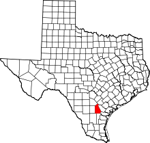 | |
| Village | ||
| Unincorporated communities | ||
| Ghost town | ||
| Footnotes | ‡This populated place also has portions in an adjacent county or counties | |
This article is issued from
Wikipedia.
The text is licensed under Creative Commons - Attribution - Sharealike.
Additional terms may apply for the media files.