Swanson railway station
Swanson | |||||||||||
|---|---|---|---|---|---|---|---|---|---|---|---|
| Auckland Transport urban rail | |||||||||||
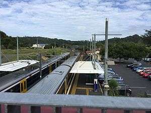 Photo of the two platforms with an EMU in each. | |||||||||||
| Location | Swanson Road, Swanson, Auckland | ||||||||||
| Owned by |
KiwiRail (track and platforms) Auckland Transport (buildings) | ||||||||||
| Line(s) | Western Line | ||||||||||
| Tracks | Main line (2) | ||||||||||
| Construction | |||||||||||
| Platform levels | 1 | ||||||||||
| Parking | No | ||||||||||
| Bicycle facilities | No | ||||||||||
| History | |||||||||||
| Opened | 18 July 1881 | ||||||||||
| Electrified | 25kV AC[1] | ||||||||||
| Traffic | |||||||||||
| Passengers (2009) | 461 passengers/day | ||||||||||
| Services | |||||||||||
| |||||||||||
Swanson railway station is a station on the North Auckland Line in Auckland, New Zealand.
Western Line services of the Auckland rail network are operated between the station and Britomart in central Auckland by Transdev, on behalf of Auckland Transport.
The station is the westernmost and northernmost point of the city's electrified network. It became the terminus of the Western Line in July 2015, when urban train services to Waitakere station ceased because the Waitakere-Swanson section of track was not electrified. A bus shuttle service operates between Waitakere and Swanson stations.[2]
The current station building was relocated from Avondale railway station following an upgrade there.
History
- 1881: The station opened on 18 July.[3]
- 1920: A signal box was built.
- 1925: Signal box destroyed by fire following a lighting strike.
- 1970: Signal box was removed.
- 1972: Closed to goods.
- 1972: Buildings replaced by a platform shelter (on opposite side to present station).
- 1995: Avondale railway station building was relocated here, now Swanson Station Cafe.
- 2000: New platform on the east side of the tracks.
- 2008: New platform on the west side of the tracks; the east side platform will be re-established to provide platforms on each side of the new double track.
- 2011: Electrification (not yet in service).
- 2014: Electrification works completed, and station energised.[1]
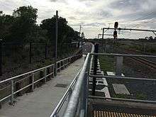
Footpath leading to a carpark.Photo faces east and is taken from platform 1.
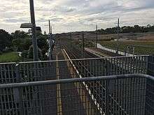
A photo of the platforms as well as tracks leading into the station. Photo faces east.
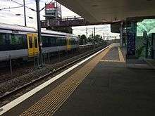
Photo of platform 2 facing east with an EMU in platform 1
See also
References
- 1 2 "Auckland Electrification Map" (PDF). KiwiRail. September 2014. Retrieved 26 September 2014.
- ↑ "Waitakere trains' passing marked with mock funeral". stuff.co.nz. 8 June 2015. Retrieved 26 April 2016.
- ↑ Scoble, Juliet (2012). Names & Opening & Closing Dates of Railway Stations in New Zealand, 1863 to 2012. Wellington. p. 124.
External links

This article is issued from
Wikipedia.
The text is licensed under Creative Commons - Attribution - Sharealike.
Additional terms may apply for the media files.