Svitávka (Blansko District)
| Svitávka | |||
|---|---|---|---|
| Městys | |||
 | |||
| |||
 Svitávka | |||
| Coordinates: 49°30′6″N 16°35′53″E / 49.50167°N 16.59806°ECoordinates: 49°30′6″N 16°35′53″E / 49.50167°N 16.59806°E | |||
| Country |
| ||
| Region | South Moravian | ||
| District | Blansko | ||
| Area | |||
| • Total | 8.26 km2 (3.19 sq mi) | ||
| Elevation | 314 m (1,030 ft) | ||
| Population (2014) | |||
| • Total | 1,812 | ||
| • Density | 220/km2 (570/sq mi) | ||
| Postal code | 379 32 | ||
| Website | http://www.svitavka.com | ||
.png)
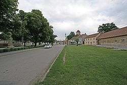
Svitávka is a market town (městys) in Blansko District in the South Moravian Region of the Czech Republic.
The town covers an area of 8.26 square kilometres (3.19 sq mi), and has a population of 1,812 (as at 2014).
Svitávka lies approximately 16 kilometres (10 mi) north of Blansko, 34 km (21 mi) north of Brno, and 170 km (106 mi) south-east of Prague.
History
The area was populated already in the stone age. The first written record is from 1284, when Vaclav II approved fortification. In year 1583, Rudolf II granted it small town status. The small town status was returned on October 10th, 2006.
References
| Wikimedia Commons has media related to Svitávka (Blansko District). |
This article is issued from
Wikipedia.
The text is licensed under Creative Commons - Attribution - Sharealike.
Additional terms may apply for the media files.