Susz
| Susz | ||
|---|---|---|
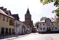 Centre of the town | ||
| ||
 Susz | ||
| Coordinates: 53°43′12″N 19°20′14″E / 53.72000°N 19.33722°E | ||
| Country |
| |
| Voivodeship | Warmian-Masurian | |
| County | Iława | |
| Gmina | Susz | |
| Area | ||
| • Total | 6.67 km2 (2.58 sq mi) | |
| Population (2006) | ||
| • Total | 5,610 | |
| • Density | 840/km2 (2,200/sq mi) | |
| Postal code | 14-240 | |
| Website | http://www.susz.pl | |
Susz [suʂ] (German: Rosenberg in Westpreußen) is a town in Iława County, Warmian-Masurian Voivodeship, Poland, with 5,600 inhabitants (2004).
Geographical location
Susz is located about 26 kilometres (16 miles) east of Kwidzyn, 48 kilometres (30 miles) south of Elbląg and 130 kilometres (81 miles) south-west of Kaliningrad at an altitude of 114 metres (374 feet) above sea level.
History
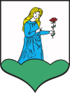
Throughout its history the town carried a rose in its coat of arms (in German Rosenberg means "rose hill").
Around 1900 the town had a Protestant church, a Catholic church and a synagogue.
After World War I, during the ongoing Polish-Bolshevik War, a plebiscite was held to determine whether the town was to be part of Germany or the Second Polish Republic on July 11, 1920. 33,498 voted to remain in Germany, 1,073 voted for Poland. Based on that result the town was included in the Regierungsbezirk Marienwerder within East Prussia. From October 26, 1939, until 1945 Rosenberg was part of Regierungsbezirk Marienwerder in the province of Reichsgau Danzig-West Prussia. During World War II Rosenberg was captured by the Red Army. After the end of war, the town became part of Poland under its Polish name Susz.
After the town had been put under Polish administration almost all German inhabitants who had remained in the town or had returned were expelled.
Notable residents
- Artur Fürst (1880–1926), German-Jewish author
Number of inhabitants by year
| Year | Number[1][2][3][4] |
|---|---|
| 1788 | 781 |
| 1829 | 1,570 |
| 1831 | 1,295 |
| 1875 | 3,081 |
| 1880 | 3,044 |
| 1885 | 3,055 |
| 1890 | 2,909 |
| 1905 | 3,259 |
| 1925 | 3,280 |
| 1933 | 3,822 |
| 1939 | 4,481 |
| 1943 | 4,440 |
| 2006 | 5,610 |
References
- ↑ Johann Friedrich Goldbeck: Vollständige Topographie des Königreichs Preußen. Teil II, Marienwerder 1789, p. 10, no. 7.
- ↑ Der Große Brockhaus, 15th edition, Vol. 16, Leipzig 1933, pp. 101–102.
- ↑ Michael Rademacher: Deutsche Verwaltungsgeschichte Provinz Westpreußen, Kreis Rosenberg (2006).
- ↑ August Eduard Preuß: Preußische Landes- und Volkskunde. Königsberg 1835, p. 440, no. 56.
Coordinates: 53°43′N 19°20′E / 53.717°N 19.333°E