Suruga-ku, Shizuoka
| Suruga 駿河区 | |
|---|---|
| Ward | |
| Suruga Ward | |
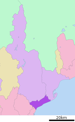 Location of Suruga-ku in Shizuoka | |
 Suruga | |
| Coordinates: 34°57′38″N 138°24′15″E / 34.96056°N 138.40417°ECoordinates: 34°57′38″N 138°24′15″E / 34.96056°N 138.40417°E | |
| Country | Japan |
| Region | Tōkai (Chūbu) |
| Prefecture | Shizuoka |
| City | Shizuoka |
| Area | |
| • Total | 73.05 km2 (28.20 sq mi) |
| Population (March 1 2018) | |
| • Total | 211,604 |
| • Density | 2,897/km2 (7,500/sq mi) |
| Time zone | UTC+9 (Japan Standard Time) |
| Phone number | 054-202-5811 |
| Address | 10-40 Minami-Yawata-cho, Suruga-ku Shizuoka-shi, Shizuoka-ken 422-8550 |
| Website | Suruga-ku home page |
Suruga-ku (駿河区 Suruga-ku) is one of three wards of Shizuoka, Shizuoka, Japan, located in the southern part of the city. The north east of Suruga-ku faces Aoi-ku; the north west faces Shimizu-ku; the south west faces Yaizu city and south east faces Suruga Bay.
Suruga-ku was created on April 1, 2005 when Shizuoka became a city designated by government ordinance (a "designated city"). It consists of the area of Shizuoka prior to its merger with Shimizu, south of the Tōkaidō Main Line rail tracks.
As of March 1 2018, Suruga-ku had a population of 211,604, with a land area of 73.05 square kilometers.
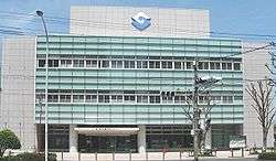
Suruga Ward Office
Education
It has a North Korean school, Shizuoka Korean Elementary and Junior High School (静岡朝鮮初中級学校).
References
| Wikimedia Commons has media related to Suruga-ku, Shizuoka. |
| Wards of Shizuoka | ||
|---|---|---|
| Wards of Hamamatsu | ||
| Special cities | ||
| Cities | ||
| Districts | ||
This article is issued from
Wikipedia.
The text is licensed under Creative Commons - Attribution - Sharealike.
Additional terms may apply for the media files.