Izunokuni
| Izunokuni 伊豆の国市 | |||
|---|---|---|---|
| City | |||
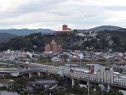 Ohito onsen in Izunokuni | |||
| |||
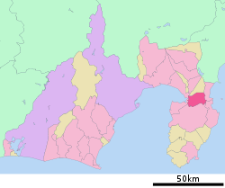 Location of Izunokuni in Shizuoka Prefecture | |||
 Izunokuni | |||
| Coordinates: 35°2′N 138°56′E / 35.033°N 138.933°ECoordinates: 35°2′N 138°56′E / 35.033°N 138.933°E | |||
| Country | Japan | ||
| Region | Chūbu (Tōkai) | ||
| Prefecture | Shizuoka Prefecture | ||
| Government | |||
| • Mayor | Toshiko Ono | ||
| Area | |||
| • Total | 94.62 km2 (36.53 sq mi) | ||
| Population (December 2016) | |||
| • Total | 47,862 | ||
| • Density | 515/km2 (1,330/sq mi) | ||
| Time zone | UTC+9 (Japan Standard Time) | ||
| - Tree | Nageia nagi | ||
| - Flower | viola | ||
| Phone number | 055-948-1413 | ||
| Address |
340-1 Nakaoka Izunokuni-shi, Shizuoka-ken 410-2292 | ||
| Website |
www | ||


Izunokuni (伊豆の国市 Izunokuni-shi) is a city located in Shizuoka Prefecture, Japan.
The city, which covers an area of 94.62 square kilometres (36.53 sq mi), had an estimated population in December 2016 of 47,862, giving a population density of 506 persons per km2.
History
During the late Heian and Kamakura periods, the town of Nirayama within the current borders of Izunokuni was the home of the Hōjō clan, which dominated Japanese politics in the 12th century. A castle was established at Nirayama by Ise Moritoki, founder of the Later Hōjō clan in 1493.During the Edo period, most of Izu Province was tenryō territory under direct control of the Tokugawa shogunate, who ruled Izu and parts of eastern Suruga Province from a daikansho established at Nirayama. After the Meiji Restoration, the area became the short-lived Nirayama Prefecture, which was merged into the equally short-lived Ashigara Prefecture in 1871. From 1876, the area has been part of Shizuoka Prefecture. During the cadastral reform of 1886, the area was reorganized into several villages under Kimisawa District, which was with Tagata District in 1896.
In 1934, Izunagaoka was elevated to town status, followed by Ōhito in 1940, and Nirayama in 1962.
The modern city of Izunokuni was created on April 1, 2005 from the merger of the towns of Izunagaoka, Nirayama and Ohito (all from Tagata District).
Geography
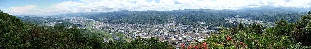
Izunokuni is located on the northern "neck" of the Izu Peninsula in eastern Shizuoka Prefecture. The region is hilly, with numerous hot springs. The climate of the region is temperate maritime, with hot, humid summers and short, cool winters, with the warm Kuroshio Current offshore having a moderating effect.
Surrounding municipalities
Economy
The economy of Izunokuni is dominated by agriculture (strawberries and tomatoes) and by tourism related to the hot spring resort industry.
Transportation
Railway
- Izuhakone Railway - Sunzu Line
- Baraki - Nirayama - Izu-Nagaoka - Ōhito - Takyō
Highway
Local attractions
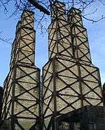
Nirayama reverberatory furnace site
A reverberatory furnace for the purpose of manufacturing cannon was built in what is now part of Izunokuni by the Bakumatsu period Tokugawa shogunate in 1857. It was officially registered as a UNESCO World Heritage Site, as one of the constituent Sites of Japan’s Meiji Industrial Revolution: Iron and Steel, Shipbuilding and Coal Mining in 2015.
Sister City relations

Notable people from Izunokuni
- Sayuri Iwata - actress
- Takanobu Hozumi - actor and voice actor
References
- ↑ UNESCO World Heritage Convention home page
External links
![]()
- Izunokuni City official website (in Japanese)
| Wards of Shizuoka | ||
|---|---|---|
| Wards of Hamamatsu | ||
| Special cities | ||
| Cities | ||
| Districts | ||