Surnadalsøra
| Surnadalsøra | |
|---|---|
| Village | |
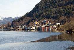 View of Surnadalsøra | |
 Surnadalsøra Location in Møre og Romsdal  Surnadalsøra Surnadalsøra (Norway) | |
| Coordinates: 62°58′13″N 08°39′41″E / 62.97028°N 8.66139°ECoordinates: 62°58′13″N 08°39′41″E / 62.97028°N 8.66139°E | |
| Country | Norway |
| Region | Western Norway |
| County | Møre og Romsdal |
| District | Nordmøre |
| Municipality | Surnadal Municipality |
| Elevation[1] | 60 m (200 ft) |
| Time zone | UTC+01:00 (CET) |
| • Summer (DST) | UTC+02:00 (CEST) |
| Post Code | 6650 Surnadal |
Surnadalsøra is a village in Surnadal Municipality in Møre og Romsdal county, Norway. It is located at the end of the Surnadalsfjorden, near the mouth of the river Surna. It is located just southwest of the villages of Sylte and Skei.[2]
Surnadalsøra is combined together with neighboring Skei as an "urban area" by Statistics Norway. The 2.4-square-kilometre (590-acre) urban area has a population (2013) of 2,423; which gives the Surnadalsøra/Skei area a population density of 1,010 inhabitants per square kilometre (2,600/sq mi).[3]
References
- ↑ "Surnadalsøra" (in Norwegian). yr.no. Retrieved 2010-12-09.
- ↑ Store norske leksikon. "Surnadalsøra" (in Norwegian). Retrieved 2010-12-09.
- ↑ Statistisk sentralbyrå (1 January 2013). "Urban settlements. Population and area, by municipality".
This article is issued from
Wikipedia.
The text is licensed under Creative Commons - Attribution - Sharealike.
Additional terms may apply for the media files.