Surenen Pass
| Surenen Pass | |
|---|---|
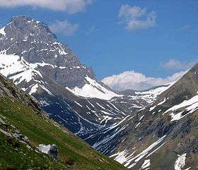 The Blackenstock (left, 2930m, in front of Brunnistock, hidden) and the Surenen Pass (center), viewed from the west | |
| Elevation | 2,292 m (7,520 ft) |
| Traversed by | Trail |
| Location | Uri, Switzerland |
| Range | Alps |
| Coordinates | 46°50′11″N 8°32′45″E / 46.83639°N 8.54583°ECoordinates: 46°50′11″N 8°32′45″E / 46.83639°N 8.54583°E |
| Topo map | swisstopo |
 Location in Switzerland | |
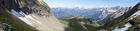
View from the pass looking towards the east
The Surenen Pass (German: Surenenpass) is a high mountain pass across the Urner Alps in the canton of Uri in Central Switzerland. The pass crosses the col between the Blackenstock (2915 m) and the Eggenmanndli (2448 m) peaks, at an elevation of 2,292 m (7,520 ft).[1]
The pass is traversed by a trail, which connects the village of Altdorf, in the canton of Uri (460 m (1,510 ft)), with the village of Engelberg, in the canton of Obwalden (1,000 m (3,300 ft)). The trail forms part of the Alpine Pass Route, a long-distance hiking trail across Switzerland between Sargans to the east and Montreux to the west of Switzerland.[1][2]
See also
References
- 1 2 map.geo.admin.ch (Map). Swiss Confederation. Retrieved 2015-05-14.
- ↑ Reynolds, Kev (2011). "Trek 10 - Alpine Pass Route". Trekking in the Alps. Cicerone. pp. 124–135. ISBN 978 1 85284 600 8.
External links

- Surenen Pass on Via Alpina web site
- Surenenpass on Hikr web site
This article is issued from
Wikipedia.
The text is licensed under Creative Commons - Attribution - Sharealike.
Additional terms may apply for the media files.