Supphellebreen
| Supphellebreen | |
|---|---|
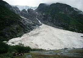 View of the Supphellebreen | |
 Location in Sogn og Fjordane | |
| Location | Sogn og Fjordane, Norway |
| Coordinates | 61°28′49″N 06°48′35″E / 61.48028°N 6.80972°ECoordinates: 61°28′49″N 06°48′35″E / 61.48028°N 6.80972°E |
Supphellebreen is a glacier in the Fjærland area in Sogndal Municipality in Sogn og Fjordane county, Norway. It is located about 10 kilometres (6.2 mi) north of the village of Fjærland.
It is located inside Jostedalsbreen National Park. It's a side branch of the main Jostedalsbreen glacier. The glacier is split into an upper and a lower part, with a non-glaciated area between. The glacier reaches down to 60 m.a.s.l., the lowest glacier level in southern Norway. The Bøyabreen glacier lies just northwest of Supphellebreen.[1]
References
- ↑ Lauritzen, Per Roger, ed. (2009). "Supphellebreen". Norsk Fjelleksikon (in Norwegian). Arendal: Friluftsforlaget. ISBN 978-82-91-49547-7.
This article is issued from
Wikipedia.
The text is licensed under Creative Commons - Attribution - Sharealike.
Additional terms may apply for the media files.