Summit Township, Monroe County, Ohio
| Summit Township, Monroe County, Ohio | |
|---|---|
| Township | |
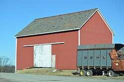 Barn on State Route 145 west of Lewisville | |
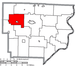 Location of Summit Township in Monroe County | |
| Coordinates: 39°46′14″N 81°13′7″W / 39.77056°N 81.21861°WCoordinates: 39°46′14″N 81°13′7″W / 39.77056°N 81.21861°W | |
| Country | United States |
| State | Ohio |
| County | Monroe |
| Area | |
| • Total | 23.0 sq mi (59.6 km2) |
| • Land | 23.0 sq mi (59.6 km2) |
| • Water | 0.0 sq mi (0.0 km2) |
| Elevation[1] | 1,247 ft (380 m) |
| Population (2010) | |
| • Total | 647 |
| • Density | 28/sq mi (11/km2) |
| Time zone | UTC-5 (Eastern (EST)) |
| • Summer (DST) | UTC-4 (EDT) |
| FIPS code | 39-75497[2] |
| GNIS feature ID | 1086659[1] |
Summit Township is one of the eighteen townships of Monroe County, Ohio, United States. As of the 2010 census, the population was 647, including 176 people in the village of Lewisville.[3]
Geography
Located in the northwestern part of the county, it borders the following townships:
- Malaga Township - north
- Center Township - east
- Wayne Township - south
- Franklin Township - southwest
- Seneca Township - northwest
The village of Lewisville is located in central Summit Township.
Name and history
It is the only Summit Township statewide.[4]
Government
The township is governed by a three-member board of trustees, who are elected in November of odd-numbered years to a four-year term beginning on the following January 1. Two are elected in the year after the presidential election and one is elected in the year before it. There is also an elected township fiscal officer,[5] who serves a four-year term beginning on April 1 of the year after the election, which is held in November of the year before the presidential election. Vacancies in the fiscal officership or on the board of trustees are filled by the remaining trustees.
References
- 1 2 "US Board on Geographic Names". United States Geological Survey. 2007-10-25. Retrieved 2008-01-31.
- ↑ "American FactFinder". United States Census Bureau. Retrieved 2008-01-31.
- ↑ "Profile of General Population and Housing Characteristics: 2010 Demographic Profile Data (DP-1): Summit township, Monroe County, Ohio". U.S. Census Bureau, American Factfinder. Retrieved June 4, 2012.
- ↑ "Detailed map of Ohio" (PDF). United States Census Bureau. 2000. Retrieved 2007-02-16.
- ↑ §503.24, §505.01, and §507.01 of the Ohio Revised Code. Accessed 4/30/2009.
External links
Municipalities and communities of Monroe County, Ohio, United States | ||
|---|---|---|
| Villages | 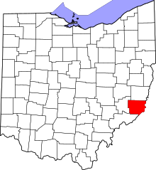 | |
| Townships | ||
| CDPs | ||
| Unincorporated communities | ||
| Ghost town | ||
| Footnotes | ‡This populated place also has portions in an adjacent county or counties | |