Sumatra, Montana
| Sumatra, Montana | |
|---|---|
| Unincorporated community | |
 Sumatra, Montana  Sumatra, Montana | |
| Coordinates: 46°37′06″N 107°33′04″W / 46.61833°N 107.55111°WCoordinates: 46°37′06″N 107°33′04″W / 46.61833°N 107.55111°W | |
| Country | United States |
| State | Montana |
| County | Rosebud |
| Elevation | 3,202 ft (976 m) |
| Time zone | UTC-7 (Mountain (MST)) |
| • Summer (DST) | UTC-6 (MDT) |
| Area code(s) | 406 |
| GNIS feature ID | 777301[1] |
Sumatra is an unincorporated community in far northwestern Rosebud County, Montana, United States.[1] It consists of a church and a post office, with respective houses, surrounded by open ranch land.
Notes
Municipalities and communities of Rosebud County, Montana, United States | ||
|---|---|---|
| Cities | 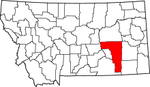 | |
| CDPs | ||
| Other unincorporated communities | ||
| Indian reservation | ||
| Ghost town | ||
| Footnotes | ‡This populated place also has portions in an adjacent county or counties | |
This article is issued from
Wikipedia.
The text is licensed under Creative Commons - Attribution - Sharealike.
Additional terms may apply for the media files.