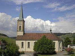
Sulz, Aargau
| Sulz | ||
|---|---|---|
| Former municipality of Switzerland | ||
 | ||
| ||
 Sulz | ||
|
Location of Sulz 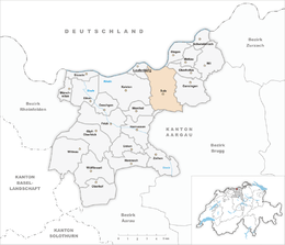 Sulz Sulz (Canton of Aargau) | ||
| Coordinates: 47°32′N 8°6′E / 47.533°N 8.100°ECoordinates: 47°32′N 8°6′E / 47.533°N 8.100°E | ||
| Country | Switzerland | |
| Canton | Aargau | |
| District | Laufenburg | |
| Area | ||
| • Total | 12.21 km2 (4.71 sq mi) | |
| Elevation | 381 m (1,250 ft) | |
| Population (December 2006) | ||
| • Total | 1,155 | |
| • Density | 95/km2 (240/sq mi) | |
| Postal code | 5085 | |
| SFOS number | 4178 | |
| Surrounded by | Elfingen, Etzgen, Gansingen, Hornussen, Ittenthal, Kaisten, Laufenburg (DE-BW), Laufenburg, Mönthal, Oberhofen | |
| Website |
www SFSO statistics | |

Sulz was a municipality in the district of Laufenburg in the canton of Aargau in Switzerland. The late Roman watchtower in Rheinsulz is listed as a heritage site of national significance.[1] On 1 January 2010 the municipality of Sulz merged into Laufenburg.[2]
References
- ↑ Swiss inventory of cultural property of national and regional significance (1995), p. 47.
- ↑ Amtliches Gemeindeverzeichnis der Schweiz, Mutationsmeldungen 2009 / Répertoire officiel des communes de Suisse, Mutations 2009 / Elenco ufficiale dei Comuni della Svizzera, Mutazione 2009 (PDF) (Report). Federal Statistical Office. 2009. 3172. Archived from the original (PDF) on 18 November 2010. Retrieved 6 March 2010.
| Wikimedia Commons has media related to Sulz. |
This article is issued from
Wikipedia.
The text is licensed under Creative Commons - Attribution - Sharealike.
Additional terms may apply for the media files.