Sukna
| Sukna | |
|---|---|
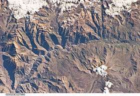 The Colca River and Sukna west of it (on the left) as seen from the ISS | |
| Highest point | |
| Elevation | 5,120 m (16,800 ft) [1] |
| Coordinates | 15°35′42″S 72°12′37″W / 15.59500°S 72.21028°WCoordinates: 15°35′42″S 72°12′37″W / 15.59500°S 72.21028°W |
| Geography | |
 Sukna Peru | |
| Location | Peru, Arequipa Region |
| Parent range | Andes |
Sukna (Quechua for friend,[2] Hispanicized spelling Sucna) is a 5,120-metre-high (16,798 ft) mountain in the Andes of Peru. It is located in the Arequipa Region, Castilla Province, on the border of the districts of Ayo and Choco. Sukna lies southwest of Qallwa.[3][3]
References
- ↑ "Cerro Icma". IGN, Peru. Retrieved August 6, 2015.
- ↑ Teofilo Laime Ajacopa, Diccionario Bilingüe Iskay simipi yuyayk'ancha, La Paz, 2007 (Quechua-Spanish dictionary) see: amigo
- 1 2 escale.minedu.gob.pe - UGEL map of the Caylloma Province 1 (Arequipa Region)
This article is issued from
Wikipedia.
The text is licensed under Creative Commons - Attribution - Sharealike.
Additional terms may apply for the media files.