Sugar Creek Township, Allen County, Ohio
| Sugar Creek Township, Allen County, Ohio | |
|---|---|
| Township | |
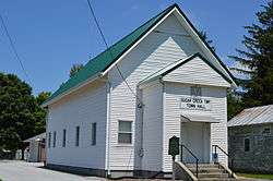 Township hall at Gomer | |
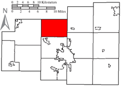 Location of Sugar Creek Township, Allen County, Ohio | |
| Coordinates: 40°49′59″N 84°10′28″W / 40.83306°N 84.17444°WCoordinates: 40°49′59″N 84°10′28″W / 40.83306°N 84.17444°W | |
| Country | United States |
| State | Ohio |
| County | Allen |
| Area | |
| • Total | 24.2 sq mi (62.7 km2) |
| • Land | 24.1 sq mi (62.4 km2) |
| • Water | 0.1 sq mi (0.3 km2) |
| Elevation[1] | 784 ft (239 m) |
| Population (2010) | |
| • Total | 1,283 |
| • Density | 53/sq mi (20.6/km2) |
| Time zone | UTC-5 (Eastern (EST)) |
| • Summer (DST) | UTC-4 (EDT) |
| FIPS code | 39-75199[2] |
| GNIS feature ID | 1085701[1] |
Sugar Creek Township is one of the twelve townships of Allen County, Ohio, United States. As of the 2010 census the population was 1,283.[3]
Geography
Located in the northern part of the county, it borders the following townships:
- Sugar Creek Township, Putnam County - north
- Monroe Township - northeast
- Bath Township - southeast
- American Township - south
- Marion Township - west
- Jennings Township, Putnam County - northwest corner
No municipalities are located in Sugar Creek Township, although the unincorporated community of Gomer lies in the township's north.
Name and history
This township took its name from Sugar Creek. It is one of five Sugar Creek Townships statewide.[4]
Government
The township is governed by a three-member board of trustees, who are elected in November of odd-numbered years to a four-year term beginning on the following January 1. Two are elected in the year after the presidential election and one is elected in the year before it. There is also an elected township fiscal officer,[5] who serves a four-year term beginning on April 1 of the year after the election, which is held in November of the year before the presidential election. Vacancies in the fiscal officership or on the board of trustees are filled by the remaining trustees.
References
- 1 2 "US Board on Geographic Names". United States Geological Survey. 2007-10-25. Retrieved 2008-01-31.
- ↑ "American FactFinder". United States Census Bureau. Retrieved 2008-01-31.
- ↑ "Geographic Identifiers: 2010 Demographic Profile Data (G001): Sugar Creek township, Allen County, Ohio". U.S. Census Bureau, American Factfinder. Retrieved July 5, 2013.
- ↑ "Detailed map of Ohio" (PDF). United States Census Bureau. 2000. Retrieved 2007-02-16.
- ↑ §503.24, §505.01, and §507.01 of the Ohio Revised Code. Accessed 4/30/2009.
External links
Municipalities and communities of Allen County, Ohio, United States | ||
|---|---|---|
| Cities | 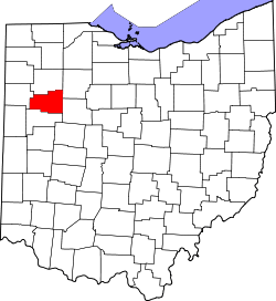 | |
| Villages | ||
| Townships | ||
| CDPs | ||
| Unincorporated communities | ||
| Footnotes | ‡This populated place also has portions in an adjacent county or counties | |