Suðureyri
| Suðureyri | |
|---|---|
| Village | |
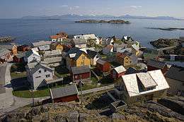
 Suðureyri, June 2008 | |
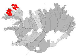 Location of the Municipality of Ísafjarðarbær | |
 Suðureyri Location of the Municipality of Ísafjarðarbær | |
| Coordinates: 66°07′N 23°32′W / 66.117°N 23.533°W | |
| Country |
|
| Constituency[1] | Northwest Constituency |
| Region[2] | Westfjords |
| Municipality | Ísafjarðarbær |
| Population (January 2011) | |
| • Total | 312 |
| Time zone | UTC+0 (GMT) |
| Póstnúmer | 430 |
Suðureyri is a small Icelandic fishing village perched on the tip of the 13 km-long Súgandafjörður in the Westfjords.
The community was isolated for years by the huge mountains and rough road that led over them. Now it is connected to Ísafjörður by a 5 km tunnel.
The village has tours set up to allow visitors to experience traditional Icelandic life firsthand. This includes going out on original fishing boats or visiting the fish factory in town.
Amenities include a geothermal swimming pool, campsite, hotel and a restaurant.
Climate
| Climate data for Suðureyri (1961-1988) | |||||||||||||
|---|---|---|---|---|---|---|---|---|---|---|---|---|---|
| Month | Jan | Feb | Mar | Apr | May | Jun | Jul | Aug | Sep | Oct | Nov | Dec | Year |
| Record high °C (°F) | 12.0 (53.6) |
12.5 (54.5) |
11.7 (53.1) |
14.2 (57.6) |
17.5 (63.5) |
20.0 (68) |
24.5 (76.1) |
22.0 (71.6) |
17.6 (63.7) |
15.0 (59) |
13.3 (55.9) |
15.0 (59) |
24.5 (76.1) |
| Average high °C (°F) | 1.4 (34.5) |
2.0 (35.6) |
1.3 (34.3) |
3.9 (39) |
7.4 (45.3) |
10.7 (51.3) |
12.5 (54.5) |
12.1 (53.8) |
8.5 (47.3) |
5.7 (42.3) |
3.1 (37.6) |
1.7 (35.1) |
5.9 (42.6) |
| Daily mean °C (°F) | −0.9 (30.4) |
−0.4 (31.3) |
−1.1 (30) |
1.5 (34.7) |
5.0 (41) |
8.1 (46.6) |
10.0 (50) |
9.5 (49.1) |
6.4 (43.5) |
3.6 (38.5) |
0.8 (33.4) |
−0.7 (30.7) |
3.5 (38.3) |
| Average low °C (°F) | −3.6 (25.5) |
−3.2 (26.2) |
−3.8 (25.2) |
−1.4 (29.5) |
2.2 (36) |
5.4 (41.7) |
7.3 (45.1) |
7.1 (44.8) |
4.2 (39.6) |
1.5 (34.7) |
−1.6 (29.1) |
−3.3 (26.1) |
0.9 (33.6) |
| Record low °C (°F) | −16.5 (2.3) |
−16.6 (2.1) |
−19.5 (−3.1) |
−17.5 (0.5) |
−7.7 (18.1) |
−2.3 (27.9) |
1.0 (33.8) |
−1.0 (30.2) |
−3.4 (25.9) |
−8.9 (16) |
−11.7 (10.9) |
−14.2 (6.4) |
−19.5 (−3.1) |
| Average precipitation mm (inches) | 127.4 (5.016) |
104.5 (4.114) |
107.4 (4.228) |
71.3 (2.807) |
35.4 (1.394) |
43.3 (1.705) |
48.2 (1.898) |
68.3 (2.689) |
102.8 (4.047) |
146.8 (5.78) |
159.3 (6.272) |
126.3 (4.972) |
1,141 (44.922) |
| Average precipitation days (≥ 0.1 mm) | 23.7 | 21.0 | 23.9 | 20.0 | 15.4 | 16.1 | 15.1 | 17.0 | 20.1 | 24.5 | 23.7 | 24.5 | 245 |
| Source #1: Icelandic Met Office [3] | |||||||||||||
| Source #2: Icelandic Met Office (precipitation days 1961-90 for Galtarviti-4 km (2.5 mi) from Suðureyri) [4] As Galtarviti gets nearly 70 millimetres (3 in) more precipitation than Suðureyri, there might be a significant difference in days with precipitation between them. | |||||||||||||
References
- ↑ Political division
- ↑ Mainly statistical division
- ↑ "Climatological Data for Suðureyri". Icelandic Meteorological Office. Retrieved 17 December 2016.
- ↑ "1961-90 Climate Normals for Galtarviti". Icelandic Meteorological Office. Retrieved 17 December 2016.
External links
This article is issued from
Wikipedia.
The text is licensed under Creative Commons - Attribution - Sharealike.
Additional terms may apply for the media files.