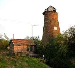
Stubb Drainage Windmill
| Stubb Drainage Windmill | |
| Windmill | |
 Stubb Drainage east of the village of Hickling | |
| Country | England |
|---|---|
| State | Norfolk |
| Region | East of England |
| District | North Norfolk |
| Municipality | Hickling |
| Location | Stubb Road, Hickling |
| - coordinates | 52°44′26″N 1°36′41″E / 52.740681°N 1.611467°ECoordinates: 52°44′26″N 1°36′41″E / 52.740681°N 1.611467°E |
| Material | Norfolk red Brick |
| Founded | c1800 |
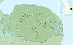 Stubb Drainage Windmill within Norfolk | |
| Map Ref: grid reference TG437220 | |
Stubb Drainage Windmill is 1.9 miles east of Hickling in the English county of Norfolk.[1] The Windmill is a Grade II listed building and was given this status on 30 September 1987.[2] The estimate is that there were once about 200 wind powered drainage windmills in the Broadlands. Stubb Drainage windmill is listed as one that is at risk of decay by Norfolk County Council.[3]
History
Stubb Windmill is a towermill which was built between the years 1795 and 1825 along with several other drainage windmills by Sir George Berney Brograve. Water discharged from Stubb mill flowed into Meadow dyke vie drains that were also constructed at the time, one of which is called the Commissioners drain. This work resulted in the loss of three small broads which were called Wigg’s, Gag’s and Hare Park Broads.
References
- ↑ OS Explorer Map OL40, 2005, The Broads, ISBN 0-319-23769-9
- ↑ Historic England. "Details from image database (223642)". Images of England. Retrieved 17 May 2009.
- ↑ /Norfolk County Council, Buildings at Risk Webpage
External links
