Strmec, Idrija
| Strmec | |
|---|---|
 Strmec Location in Slovenia | |
| Coordinates: 45°54′30.83″N 14°1′25.46″E / 45.9085639°N 14.0237389°ECoordinates: 45°54′30.83″N 14°1′25.46″E / 45.9085639°N 14.0237389°E | |
| Country |
|
| Traditional region | Littoral |
| Statistical region | Gorizia |
| Municipality | Idrija |
| Area | |
| • Total | 2.85 km2 (1.10 sq mi) |
| Elevation | 845.2 m (2,773.0 ft) |
| Population (2002) | |
| • Total | 26 |
| [1] | |
Strmec (pronounced [ˈstəɾməts], in older sources also Strmica,[2] German: Stermza[2]) is a small dispersed settlement in the hills south of Črni Vrh in the Municipality of Idrija in the traditional Littoral region of Slovenia.[3]
Strmec belongs to the cadastral municipality of Kanji Dol. Strmec has 12 numbered houses with traditional oeconyms: pri Šemrl (or Vodnar; no. 1), Tič (no. 2), Cenck (no. 3), Medved (no. 4), Podobnik (no. 5), Peter (no. 6), Skokec (no. 7), Štorc (no. 8), Skalar (no. 9), Renk (no. 10), Zajc (no. 11), and Strmec (no. 12). The Skalar house is now in ruins and it is no longer officially numbered. It was assigned number 8 c. 1823, but was reassigned the number 9 in 1959.
Gallery
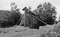 Podobnik hayrack, Strmec 5, 1959
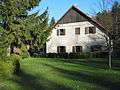 Peter farm, Strmec 6
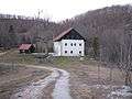 Skokec farm, Strmec 7
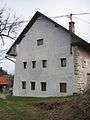 Štorc farm, Strmec 8
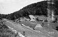 Skalar house, Strmec 9, 1959
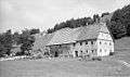 Zajec house, Strmec 11, 1959
References
- ↑ Statistical Office of the Republic of Slovenia
- 1 2 Leksikon občin kraljestev in dežel zastopanih v državnem zboru, vol. 6: Kranjsko. 1906. Vienna: C. Kr. Dvorna in Državna Tiskarna, p. 124.
- ↑ Idrija municipal site
External links
| Settlements | Administrative centre: Idrija
|  |
|---|---|---|
| Landmarks |
| |
| Notable people | ||
This article is issued from
Wikipedia.
The text is licensed under Creative Commons - Attribution - Sharealike.
Additional terms may apply for the media files.