Stretton-on-Fosse
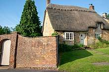
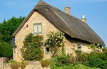
Stretton-on-Fosse is a small village and civil parish with fewer than 200 houses,[1] most built of Cotswold stone or locally-made red brick, situated on the Warwickshire-Gloucestershire border on the fringe of the Cotswold Hills. The population of the civil parish taken at the 2011 census was 439.[2] By comparison, the 1931 population was 282.[3] The village has about 200 buildings, made of Cottswold stone or locally made red bricks.[4] Of these, 18 are Grade II Listed.[5]
It is not to be confused with the other Warwickshire village of a similar name, Stretton-under-Fosse.
History
Stretton means "settlement on a Roman Road" (from the Old English stræt and tun). In this case the road is Fosse Way.
Two of the manors in Stratone as the village was then called using its Saxon name[6] are listed in the Domesday Book of 1086; of these only one remains adjoining the imposing Stretton House on the higher ground (125m) of the village. Whilst the lower ground of the village is heavy clay the upper parts are composed of sand and shingle. During commercial extraction of sand important graves of the Roman-British and Anglo-Saxon periods were uncovered and interesting skeletons and personal belongings were unearthed . These burials were the result of internecine warfare between local tribal factions.[7][8]
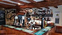
The village web site indicates that until recently, the community consisted of several farms, with housing for local residents occupied in cultivation of the land and the trade association of the rural economy, such as, shops, post-office, school,[9] inns, blacksmith, and three religious buildings. However, of these, only the Church of St. Peter and the 17th Century Plough Inn (owned in 2018 by Steve and Mandy Aubrey)[10] are still used for their intended purpose.[11][12] In 1826 a tramway with horse-drawn cars passed through the village; later, a branch line railway made a stop in the village.[13]
A new village hall was built in 1990 to replace the post-war wooden hut.[14] The old railway line and station are now gone.[15][16]
The largely deserted medieval village of Ditchford Frary is also part of the civil parish; at one time, it included St. Giles at Ditchford Frary[17] chapel. The chapel became ruinous by 1642 and was annexed to Stretton.[18][19]
Religion
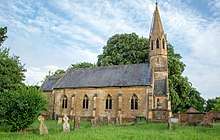
The site contained a church since the late 12th when it was presented to residents by Ralph le Breton. Originally, it was a chapel of the nearby village of Blockley.[20] The current Grade II Listed building, made of Cotswold stone and roofed with slate, was erected in the late 16th Century. Since then, it has been extensively modified; in 1841, for example, it was rebuilt and enlarged.[21] A 1949 description of the building provides these specifics:[22]
The parish church of ST. PETER ... consists of a chancel with a south vestry, nave (50 ft. long), and a west porch and bell-turret. No ancient architectural features remain. The small chancel has a traceried east window of four lights; the nave, divided by buttresses into four bays, has a two-light window in each bay in the north and south walls. The entrance is at the west end from a porch that is flanked by a small north chamber and a south staircase to a gallery. Over the porch is an octagonal bell-turret lighted by windows in gables, the whole crowned by a small stone spire. The walls are of ashlar, the roofs covered with slates.
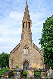
A recent report describes the interior of this Grade II listed church:[23]
The interior is simple and unpretentious, and darker than one might expect despite it's cream-washed walls (in this case owing to adjacent trees on the south side, rather than an abundance of stained glass, the usual culprit!). The furnishings are mostly of a piece with the building, including the west gallery which supports a modest organ. The only later additions appear to be the mural painting that enlivens the paneling behind the altar (eucharistic symbols along with SS Peter & Paul, difficult to appreciate in the low lighting) and the two stained glass windows at the east end of the nave (late 19th and early 20th centuries respectively).[24]
Transportation
By 1825 the Great Western Railway operated a train between Stratford-upon-Avon and Moreton-in-Marsh, and it passed through the village. At a later date a branch line was constructed to Shipston-on-Stour which was used for passengers until 1929 and goods until 1960. The Stratford and Moreton Tramway also stopped at Stretton.[25]
References
- ↑ http://www.strettononfosse.com/abouthistory/4571937067
- ↑ "Civil Parish population 2011". Retrieved 1 January 2016.
- ↑ http://www.british-history.ac.uk/vch/warks/vol5/pp153-157
- ↑ http://www.strettononfosse.com/abouthistory/4571937067
- ↑ https://www.britishlistedbuildings.co.uk/england/stretton-on-fosse-stratford-on-avon-warwickshire#.WzP2gNVKipr
- ↑ https://books.google.ca/books?id=0eo8AAAAIAAJ&pg=PA75&dq=stretton+on+fosse+stratone+domesday+book&hl=en&sa=X&ved=0ahUKEwiT9-uT6_TbAhWF44MKHXNtAOEQ6AEIODAD#v=onepage&q=stretton%20on%20fosse%20stratone%20domesday%20book&f=false
- ↑ http://www.british-history.ac.uk/vch/warks/vol5/pp153-157
- ↑ http://www.strettononfosse.com/abouthistory/4571937067
- ↑ https://www.ourwarwickshire.org.uk/content/catalogue_wow/stretton-on-fosse-schools
- ↑ http://www.strettononfosse.com/the-plough-inn/4594239947
- ↑ https://www.ourwarwickshire.org.uk/content/catalogue_her/church-of-st-peter-stretton-on-fosse
- ↑ http://www.strettononfosse.com/abouthistory/4571937067
- ↑ http://www.strettononfosse.com/abouthistory/4571937067
- ↑ https://www.ourwarwickshire.org.uk/content/catalogue_wow/stretton-on-fosse-village-hall
- ↑ http://www.strettononfosse.com/abouthistory/4571937067
- ↑ https://www.ourwarwickshire.org.uk/content/catalogue_wow/stretton-on-fosse-railway-station
- ↑ http://www.british-history.ac.uk/vch/warks/vol5/pp153-157
- ↑ https://www.ourwarwickshire.org.uk/content/catalogue_her/medieval-chapel-at-ditchford-frary
- ↑ http://www.british-history.ac.uk/vch/warks/vol5/pp153-157#h3-0003
- ↑ http://www.british-history.ac.uk/vch/warks/vol5/pp153-157#h3-0003
- ↑ https://warwickshirechurches.weebly.com/stretton-on-fosse---st-peter.html
- ↑ http://www.british-history.ac.uk/vch/warks/vol5/pp153-157
- ↑ https://www.britishlistedbuildings.co.uk/101024080-church-of-st-peter-stretton-on-fosse
- ↑ https://warwickshirechurches.weebly.com/stretton-on-fosse---st-peter.html
- ↑ http://www.british-history.ac.uk/vch/warks/vol5/pp153-157
External links
![]()
Coordinates: 52°02′38″N 1°40′41″W / 52.044°N 1.678°W