Storstrommen (Greenland)
| Storstrømmen | |
|---|---|
 Location within Greenland | |
| Type | Piedmont glacier |
| Location | Greenland |
| Coordinates | 77°0′N 22°40′W / 77.000°N 22.667°WCoordinates: 77°0′N 22°40′W / 77.000°N 22.667°W |
| Area | 32,100 km2 |
| Length | 125 km |
| Width | 26 km |
| Terminus |
Borge Fjord through Bredebrae; North Atlantic Ocean |
Storstrommen (Danish: Storstrømmen; "Large Stream"), is one of the major glaciers in northeastern Greenland.[1]
It was named Storstrømmen because of its size by the ill-fated 1906–08 Denmark Expedition (Danmark-Ekspeditionen) led by Ludvig Mylius-Erichsen.[2]
Geography
The mighty Storstrommen is roughly north-south oriented and has a width of over 20 km. Queen Louise Land (Dronning Louise Land) lies to the west and Daniel Bruun Land to the east.[2]
Flowing southwards for over 125 kilometers, its front is in the Bredebrae,[3] the confluence of two very large glaciers, the Storstrommen flowing from the north and the almost equally large L. Bistrup Brae from the south.[2]
The Storstrommen is part of an extensive glacier system that includes as well the Kofoed-Hansen Glacier (Kofoed-Hansen Bræ) to the NE and the Borgjokel Glacier to the SW.[3][4][5]
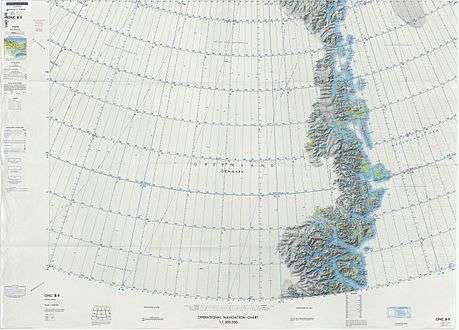 Map of Northeastern Greenland. |
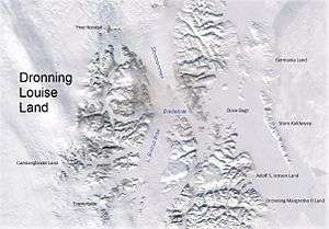 Storstrommen east of Queen Louise Land. |
See also
References
- ↑ "Storstrømmen". Mapcarta. Retrieved 21 April 2016.
- 1 2 3 "Catalogue of place names in northern East Greenland". Geological Survey of Denmark. Retrieved 21 April 2016.
- 1 2 Fluctuations of Glaciers 1990-1995 (Vol. VII)
- ↑ Storstrømmen susceptible to rapid retreat
- ↑ Neoglacial glacier changes around Storstrommen, North-East Greenland