Storfosna
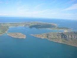 View of the island (looking north) | |
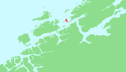 | |
 Storfosna Location of the island  Storfosna Storfosna (Norway) | |
| Geography | |
|---|---|
| Location | Trøndelag, Norway |
| Coordinates | 63°40′04″N 9°24′25″E / 63.6678°N 09.4070°ECoordinates: 63°40′04″N 9°24′25″E / 63.6678°N 09.4070°E |
| Area | 11 km2 (4.2 sq mi) |
| Length | 6 km (3.7 mi) |
| Width | 3 km (1.9 mi) |
| Highest elevation | 158 m (518 ft) |
| Highest point | Fosenfjellet |
| Administration | |
|
Norway | |
| County | Trøndelag |
| Municipality | Ørland |
Storfosna is a populated island in the municipality of Ørland in Trøndelag county, Norway. The 11-square-kilometre (4.2 sq mi) island is located between the islands of Kråkvåg and Garten north of the mouth of the Trondheimsfjorden. The traditional district of Fosen is named after this island. There is a large deer population on the island.[1]
The island is connected to the island of Kråkvåg by a causeway and bridge, and is connected to Garten (and the mainland) by a car ferry. The Storfosna Church is located on the island.
See also
References
- ↑ Haugen, Morten, ed. (2017-08-20). "Storfosna". Store norske leksikon (in Norwegian). Kunnskapsforlaget. Retrieved 2018-02-24.
This article is issued from
Wikipedia.
The text is licensed under Creative Commons - Attribution - Sharealike.
Additional terms may apply for the media files.