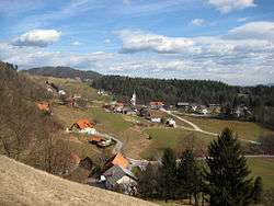
Stopnik, Vransko
| Stopnik | |
|---|---|
 | |
 Stopnik Location in Slovenia | |
| Coordinates: 46°15′31.55″N 14°58′57.44″E / 46.2587639°N 14.9826222°ECoordinates: 46°15′31.55″N 14°58′57.44″E / 46.2587639°N 14.9826222°E | |
| Country |
|
| Traditional region | Styria |
| Statistical region | Savinja |
| Municipality | Vransko |
| Area | |
| • Total | 3.86 km2 (1.49 sq mi) |
| Elevation | 355.8 m (1,167.3 ft) |
| Population (2002) | |
| • Total | 174 |
| [1] | |
Stopnik (pronounced [ˈstoːpnik]) is a settlement in the Municipality of Vransko in central Slovenia. The area is part of the traditional region of Styria. The municipality is now included in the Savinja Statistical Region.[2]
The local church is dedicated to Saints Hermagoras and Fortunatus and belongs to the Parish of Vransko. It dates to the 15th century with some 17th- and 19th-century rebuilding.[3]
To the west of the settlement are also the ruins of Stopnik Castle, first mentioned in the 12th century and abandoned around 1800.[4]
References
- ↑ Statistical Office of the Republic of Slovenia
- ↑ Vransko municipal site
- ↑ Slovenian Ministry of Culture register of national heritage reference number ešd 3506
- ↑ Slovenian Ministry of Culture register of national heritage reference number ešd 10415
External links
| Settlements | 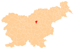 | |
|---|---|---|
| Landmarks |
| |
This article is issued from
Wikipedia.
The text is licensed under Creative Commons - Attribution - Sharealike.
Additional terms may apply for the media files.