Stonebarrow Hill
| Stonebarrow Hill | |
|---|---|
 Stonebarrow Hill | |
| Highest point | |
| Elevation | 148 m (486 ft) |
| Parent peak | Hardown Hill |
| Geography | |
| Location | Dorset, England |
| Parent range | South Dorset Downs |
| OS grid | SY396936 |
| Topo map | OS Landranger 193 |
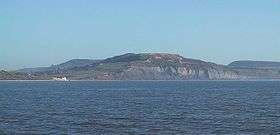
Stonebarrow Hill is a hill, east of Charmouth, near the Dorset coast in southern England. It has a height of 148 metres (486 ft) and forms the west-southwestern spur of Chardown Hill. Stonebarrow and the surrounding area is notable for its landslides.[1] The hill is often a starting point for walks around the Golden Cap estate.[2]
There is a National Trust Centre at Stonebarrow Hill and also a permanent orienteering course established by Wimborne Orienteers in conjunction with the Trust.[3]
References
- ↑ Landslides at Stonebarrow Hill, Dorset, retrieved 12 Feb 2016.
- ↑ Golden Cap, Stonebarrow Hill - The National Trust, retrieved 12 February 2016
- ↑ Stonebarrow Hill, Charmouth, Dorset - Permanent Orienteering Course, retrieved 12 Feb 2016.
External links
- Landslide at Stonebarrow Hill, Dorset British Geological Survey
This article is issued from
Wikipedia.
The text is licensed under Creative Commons - Attribution - Sharealike.
Additional terms may apply for the media files.