Stokesay Court
Stokesay Court is a country house and estate in the parish of Onibury (but named after Stokesay) in Shropshire, England.
History
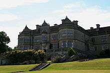
Stokesay Court was built by the rich Victorian era merchant, philanthropist, social conservative, Christian evangelist and church-builder John Derby Allcroft. He had had London churches built including St Matthew's, Bayswater, St Jude's Church, Kensington (now St Mellitus College), and St Martin's, Gospel Oak and served as Treasurer and major benefactor to Christ's Hospital school. He purchased the estate (including Stokesay Castle, which he felt unsuitable to reside in) and a small house (too small for his large family) in 1868, a smaller adjoining site in 1874, and non-adjoining land that he chose for his mansion in 1886.
The site looks out over Ludlow and the Clee Hills. Work lasted from 1889 to 1892 under the architect Thomas Harris, finishing only six months before Derby Allcroft's death. The house was one of England's first to have integral electric light, installed by Edmundsons in 1891. The house passed to John's son Herbert and then grandchildren Russell and then Jewell Magnus, acting as an Auxiliary Military Hospital for convalescent soldiers during the First World War and as a temporary home for the evacuated students of Lancing College and a Western Command Junior Leaders’ School during the Second World War. Rotating living in parts of the house in the inter-war and post-war periods, the family sold the house's original contents in a four day sale at Sotheby's in 1994 to fund building repairs. The house is currently owned by Caroline Magnus, niece of Philip Magnus-Allcroft.[1]
The house served as the home of the Tallis family in the film Atonement including its pool fountain which was temporarily altered.[2]
See also
References
- ↑ "Shropshire movies: Atonement at Stokesay Court" BBC Local News, 21 March 2010, with photograph of garden.
- ↑ "Atonement". The Castles and Manor Houses of Cinema's Greatest Period Films. Architectural Digest. January 2013. Retrieved January 2, 2013.
External links
Coordinates: 52°24′11″N 2°49′05″W / 52.402943°N 2.818111°W