Stoke to Market Drayton Line
| Stoke to Market Drayton Line | ||||||||||||||||||||||||||||||||||||||||||||||||||||||||||||||||||||||||||||||||||||||||||||||||||||||||||||||||||||||||||||||||||||||||||||||||||||||||||||||||||
|---|---|---|---|---|---|---|---|---|---|---|---|---|---|---|---|---|---|---|---|---|---|---|---|---|---|---|---|---|---|---|---|---|---|---|---|---|---|---|---|---|---|---|---|---|---|---|---|---|---|---|---|---|---|---|---|---|---|---|---|---|---|---|---|---|---|---|---|---|---|---|---|---|---|---|---|---|---|---|---|---|---|---|---|---|---|---|---|---|---|---|---|---|---|---|---|---|---|---|---|---|---|---|---|---|---|---|---|---|---|---|---|---|---|---|---|---|---|---|---|---|---|---|---|---|---|---|---|---|---|---|---|---|---|---|---|---|---|---|---|---|---|---|---|---|---|---|---|---|---|---|---|---|---|---|---|---|---|---|---|---|---|---|
| ||||||||||||||||||||||||||||||||||||||||||||||||||||||||||||||||||||||||||||||||||||||||||||||||||||||||||||||||||||||||||||||||||||||||||||||||||||||||||||||||||
The Stoke to Market Drayton Line was a railway line that ran through Staffordshire and Shropshire that was built by the North Staffordshire Railway. The closure of the station in Newcastle-under-Lyme made the town the largest borough in the United Kingdom not to have a railway station.
Construction
The first part of the line to be built required the private Silverdale & Newcastle Railway, built in 1850 by ironmaster Ralph Sneyd, to become public. This was enabled by an Act of 1859 and passenger services from Stoke to Newcastle began in 1862. Silverdale was reached in May 1863.[1]
Meanwhile, the Great Western Railway was planning a to reach Manchester and in an effort to block this, the Market Drayton extension was completed in February 1870.[1]
Services
The early years of the 20th century were the busiest, there being thirteen trains daily from Stoke to Silverdale and five to Market Drayton.[2]
Railmotor services began in 1905 and several new halts were built. Running from Silverdale as far as Trentham, they were intended to compete with trams and were somewhat successful in this respect, although they only lasted until 1926.[1]
The section between Silverdale and Pipe Gate was reduced to single track in October 1934.[1]
Dwindling passenger numbers after World War II meant that there were only two trains daily from Stoke to Market Drayton, and services ceased on 7 May 1956 when they were cut back to Silverdale.[1] Passenger services to the latter ceased in 1964, a casualty of the Beeching Axe.
Freight traffic
Express Dairies had a creamery with private siding access to Pipe Gate, allowing its preferred transport partner the GWR to provide milk trains to the facility, for onward scheduling to London.
Following nationalisation there was a very considerable increase in freight traffic on this route reaching a peak of 10,000 tons weekly in 1962-63.[1]
In 1962 a new "chord" line was opened at Madeley to provide a connection to the West Coast Main Line. This was used as a diversionary route when the Harecastle diversion line was being constructed and continued in use for freight workings once the latter was completed.
After closure of the creamery at Pipe Gate, the route between Market Drayton and Madeley Chord closed for good in 1966.[2] That same year, the line between Newcastle Junction (Stoke) and Brampton Sidings was closed and the junction severed in preparation for the West Coast Main Line electrification.[3] The Pool Dam branch survived until 7 October 1967.[1]
Final years
The last traffic on the line was coal from Apedale and Silverdale collieries, which ceased in December 1998 when the latter was closed.
Present Day
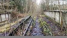
As of 2013, the line remains extant but out of use between the eastern portal of Silverdale Tunnel & just west of Madeley Road station. The line is also extant, and now a 'green lane' public footpath, from its start in Stoke-on-Trent (Cockshot Lock / Newcastle Junction) to the modern Shelton New Road.
The station at Norton In Hales is the only station still standing on the former route as a private residence. The station site at Newcastle-Under-Lyme has been landscaped and Market Drayton has been demolished and built on by both Morrisons and an industrial complex.
The platforms at Silverdale were recently added in 2009 following clearance of vegetation and the lifting of the derelict track from the former station site to the tunnel portal but the track remains intact between Silverdale and Pipe Gate via Keele and Madeley Road.
Stations
References
- 1 2 3 4 5 6 7 Christiansen, Rex; Miller, R. W. (1971). The North Staffordshire Railway. Newton Abbot: David & Charles. ISBN 0-7153-5121-4.
- 1 2 Noel R. Walley (2003). "North Staffordshire Railway Passenger Services 1910 - 1999". Retrieved 2009-05-18.
- ↑ Ballantyne, Hugh (2005). British Railways Past & Present: North Staffordshire and the Trent Valley. Past & Present Publishing Ltd. ISBN 1-85895-204-2.
- 1 2 3 4 5 6 7 8 9 10 11 12 13 14 15 Ordnance Survey (1902). "1902 Map of Staffordshire". Retrieved 2013-08-27.