Stojadła
| Stojadła | |
|---|---|
| Village | |
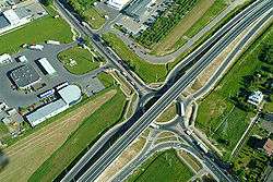 Crossing of National road 50 with National road 92 | |
 Stojadła | |
| Coordinates: 52°11′N 21°32′E / 52.183°N 21.533°E | |
| Country |
|
| Voivodeship | Masovian |
| County | Mińsk |
| Gmina | Gmina Mińsk Mazowiecki |
Stojadła [stɔˈjadwa] is a village in the administrative district of Gmina Mińsk Mazowiecki, within Mińsk County, Masovian Voivodeship, in east-central Poland.[1] It lies approximately 3 kilometres (2 mi) west of Mińsk Mazowiecki and 37 km (23 mi) east of Warsaw.
References

Coordinates: 52°11′N 21°32′E / 52.183°N 21.533°E
This article is issued from
Wikipedia.
The text is licensed under Creative Commons - Attribution - Sharealike.
Additional terms may apply for the media files.