Steinberg, Saxony
| Steinberg | ||
|---|---|---|
| ||
 Steinberg Location of Steinberg within Vogtlandkreis district 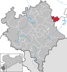  | ||
| Coordinates: 50°32′20″N 12°28′40″E / 50.53889°N 12.47778°ECoordinates: 50°32′20″N 12°28′40″E / 50.53889°N 12.47778°E | ||
| Country | Germany | |
| State | Saxony | |
| District | Vogtlandkreis | |
| Government | ||
| • Mayor | Bernd Roßberg (CDU) | |
| Area | ||
| • Total | 20.37 km2 (7.86 sq mi) | |
| Elevation | 596 m (1,955 ft) | |
| Population (2017-12-31)[1] | ||
| • Total | 2,814 | |
| • Density | 140/km2 (360/sq mi) | |
| Time zone | CET/CEST (UTC+1/+2) | |
| Postal codes | 08237 | |
| Dialling codes | 037462 | |
| Vehicle registration | V | |
| Website | www.gemeinde-steinberg.de | |

Steinberg is a municipality in the Vogtlandkreis district, in Saxony, Germany. It was established in 1994 by the merger of the three villages Rothenkirchen, Wernesgrün and Wildenau and named after the nearby Steinberg (661m/2168 ft), part of the Ore Mountains.
Wernesgrün is home of the Wernesgrüner brewery.
.jpg)
District Wildenau in Steinberg
References
- ↑ "Aktuelle Einwohnerzahlen nach Gemeinden 2017] (Einwohnerzahlen auf Grundlage des Zensus 2011)" (PDF). Statistisches Landesamt des Freistaates Sachsen (in German). October 2018.
This article is issued from
Wikipedia.
The text is licensed under Creative Commons - Attribution - Sharealike.
Additional terms may apply for the media files.