Auerbach (Vogtland)
| Auerbach | ||
|---|---|---|
 | ||
| ||
 Auerbach | ||
| Coordinates: 50°30′34″N 12°24′0″E / 50.50944°N 12.40000°ECoordinates: 50°30′34″N 12°24′0″E / 50.50944°N 12.40000°E | ||
| Country | Germany | |
| State | Saxony | |
| District | Vogtlandkreis | |
| Government | ||
| • Mayor | Manfred Deckert | |
| Area | ||
| • Total | 55.52 km2 (21.44 sq mi) | |
| Elevation | 555 m (1,821 ft) | |
| Population (2017-12-31)[1] | ||
| • Total | 18,562 | |
| • Density | 330/km2 (870/sq mi) | |
| Time zone | CET/CEST (UTC+1/+2) | |
| Postal codes | 08209 | |
| Dialling codes | 03744 | |
| Vehicle registration | V, AE | |
| Website | www.stadt-auerbach.de | |

Auerbach (German pronunciation: [ˈaʊ.ɐbax] (![]()
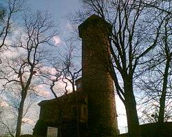
Auerbach was mentioned for the first time in 1282. The town is situated at the declivities above the river Göltzsch at the foot of a castle tower from the 12th century. Landmarks include the towers of the St. Laurentius church, the Catholic Zum Heiligen Kreuz church and the 43.9-metre-high (144 ft) tower of the castle. The three tall buildings give Auerbach its nickname “the Three Towers Town”.
Demographics
Historical population (from 1960, as on 31 December):
|
1834 bis 1960
|
1971 bis 2008
|
ab 2012
|
Datasource from 1998 on: Statistisches Landesamt Sachsen
1 29 October
2 31 August
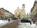 Auerbach, Vogtland
 Auerbach Castle
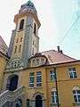 Zum Heiligen Kreuz Church
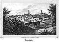 Auerbach, lithographie from a drawing by Carl Wilhelm Arldt, 1839
References
- ↑ "Aktuelle Einwohnerzahlen nach Gemeinden 2017] (Einwohnerzahlen auf Grundlage des Zensus 2011)" (PDF). Statistisches Landesamt des Freistaates Sachsen (in German). October 2018.
External links
| Authority control |
|---|