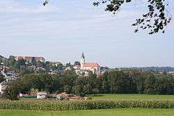
Steinakirchen am Forst
| Steinakirchen am Forst | ||
|---|---|---|
 | ||
| ||
 Steinakirchen am Forst Location within Austria | ||
| Coordinates: 48°04′00″N 15°02′50″E / 48.06667°N 15.04722°ECoordinates: 48°04′00″N 15°02′50″E / 48.06667°N 15.04722°E | ||
| Country | Austria | |
| State | Lower Austria | |
| District | Scheibbs | |
| Government | ||
| • Mayor | Johann Schagerl (ÖVP) | |
| Area | ||
| • Total | 34.96 km2 (13.50 sq mi) | |
| Elevation | 324 m (1,063 ft) | |
| Population (1 January 2016)[1] | ||
| • Total | 2,287 | |
| • Density | 65/km2 (170/sq mi) | |
| Time zone | UTC+1 (CET) | |
| • Summer (DST) | UTC+2 (CEST) | |
| Postal code | 3261 | |
| Area code | 07488 | |
| Vehicle registration | SB | |
Steinakirchen am Forst is a municipality in the district of Scheibbs in the Austrian state of Lower Austria.
Population
| Historical population | ||
|---|---|---|
| Year | Pop. | ±% |
| 1971 | 2,091 | — |
| 1981 | 2,119 | +1.3% |
| 1991 | 2,319 | +9.4% |
| 2001 | 2,370 | +2.2% |
References
- ↑ Statistik Austria - Bevölkerung zu Jahresbeginn 2002-2016 nach Gemeinden (Gebietsstand 1.1.2016) for Steinakirchen am Forst.
This article is issued from
Wikipedia.
The text is licensed under Creative Commons - Attribution - Sharealike.
Additional terms may apply for the media files.