Stateline, Idaho
| Stateline | |
|---|---|
| City | |
| City of State Line | |
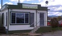 Former City Hall | |
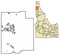 Location of Stateline in Kootenai County, Idaho. | |
 Stateline Location in the United States | |
| Coordinates: 47°42′18″N 117°2′17″W / 47.70500°N 117.03806°WCoordinates: 47°42′18″N 117°2′17″W / 47.70500°N 117.03806°W | |
| Country | United States |
| State | Idaho |
| County | Kootenai |
| Incorporated | 1947 |
| Area[1] | |
| • City | 0.11 sq mi (0.29 km2) |
| • Land | 0.11 sq mi (0.29 km2) |
| • Water | 0.00 sq mi (0.00 km2) |
| Population (2010)[2] | |
| • City | 38 |
| • Estimate (2016)[3] | 44 |
| • Density | 400.00/sq mi (154.29/km2) |
| • Metro | 144,265 (US: 283th) |
| • CSA | 679,989 (US: 71st) |
| Time zone | UTC-8 (Pacific (PST)) |
| • Summer (DST) | UTC-7 (PDT) |
| ZIP code | 83854 |
| Area code(s) | 208 |
| FIPS code | 16-77050 |
Stateline, officially the City of State Line,[4][5] and historically known as State Line Village,[6] is a city in Kootenai County, Idaho, United States, and is both the easternmost suburb of Spokane, Washington and the westernmost suburb of Coeur d'Alene, Idaho. The population was 38 at the 2010 census. The city is known for the adult services it provides which attract business from nearby Spokane and Coeur d'Alene.[7][8] The unincorporated community of Spokane Bridge, Washington is located directly across the Spokane River to the southwest.
History
Stateline, located along U.S. Route 10, was incorporated in 1947 so that it could sell liquor and have slot machines. It had a population of 137 at the time.[9]
Geography
Stateline is located at 47°42′18″N 117°2′17″W / 47.70500°N 117.03806°W (47.705131, -117.037933).[10]
According to the United States Census Bureau, the city has a total area of 0.10 square miles (0.26 km2), all land.[11]
Demographics
| Historical population | ||
|---|---|---|
| Year | Pop. | ±% |
| 1947 | 137 | — |
| 1950 | 52 | −62.0% |
| 1960 | 33 | −36.5% |
| 1970 | 22 | −33.3% |
| 1980 | 26 | +18.2% |
| 1990 | 26 | +0.0% |
| 2000 | 28 | +7.7% |
| 2010 | 38 | +35.7% |
| 2016 | 44 | +15.8% |
| U.S. Decennial Census[12] Source: [3] | ||
2010 census
As of the census[2] of 2010, there were 38 people, 20 households, and 9 families residing in the city. The population density was 380.0 inhabitants per square mile (146.7/km2). There were 21 housing units at an average density of 210.0 per square mile (81.1/km2). The racial makeup of the city was 100.0% White.
There were 20 households of which 25.0% had children under the age of 18 living with them, 20.0% were married couples living together, 15.0% had a female householder with no husband present, 10.0% had a male householder with no wife present, and 55.0% were non-families. 40.0% of all households were made up of individuals and 20% had someone living alone who was 65 years of age or older. The average household size was 1.90 and the average family size was 2.56.
The median age in the city was 41.5 years. 23.7% of residents were under the age of 18; 0.0% were between the ages of 18 and 24; 34.2% were from 25 to 44; 15.8% were from 45 to 64; and 26.3% were 65 years of age or older. The gender makeup of the city was 55.3% male and 44.7% female.
2000 census
As of the census[13] of 2000, there were 28 people, 11 households, and 5 families residing in the city. The population density was 449.9 people per square mile (180.2/km²). There were 12 housing units at an average density of 192.8 per square mile (77.2/km²). The racial makeup of the village was 85.71% White, 3.57% Native American, 7.14% from other races, and 3.57% from two or more races. Hispanic or Latino of any race were 10.71% of the population.
There were 11 households out of which 45.5% had children under the age of 18 living with them, 27.3% were married couples living together, 9.1% had a female householder with no husband present, and 54.5% were non-families. 27.3% of all households were made up of individuals and none had someone living alone who was 65 years of age or older. The average household size was 2.55 and the average family size was 3.40.
In the city, the population was spread out with 32.1% under the age of 18, 10.7% from 18 to 24, 42.9% from 25 to 44, and 14.3% from 45 to 64. The median age was 30 years. For every 100 females, there were 211.1 males. For every 100 females age 18 and over, there were 137.5 males.
The median income for a household in the city was $46,250, and the median income for a family was $23,750. Males had a median income of $30,938 versus $20,833 for females. The per capita income for the city was $16,758. There were no families and 26.3% of the population living below the poverty line, including no under eighteens and none of those over 64.
References
- ↑ "2016 U.S. Gazetteer Files". United States Census Bureau. Retrieved Jul 26, 2017.
- 1 2 "American FactFinder". United States Census Bureau. Retrieved 2012-12-18.
- 1 2 "Population and Housing Unit Estimates". Retrieved June 9, 2017.
- ↑ "Feature Detail Report for: City of State". GNIS. Retrieved July 17, 2018.
- ↑ "Kootenai County City Clerks". Coeur d'Alene. Retrieved May 9, 2018.
- ↑ "Feature Detail Report for: State Line Village". GNIS. Retrieved July 17, 2018.
- ↑ "State Line, Idaho Hopes Highway Won't Kill Town". Tri City Herald. 17 March 1977.
- ↑ Titone, Julie (28 February 2000). "Rally Protests Nude Dancers". The Spokesman-Review. Retrieved 23 June 2011.
- ↑ "State Line, One of Idaho's Newest Incorporated Towns". The Spokesman-Review. 4 December 1947. Retrieved 23 April 2012.
- ↑ "US Gazetteer files: 2010, 2000, and 1990". United States Census Bureau. 2011-02-12. Retrieved 2011-04-23.
- ↑ "US Gazetteer files 2010". United States Census Bureau. Archived from the original on 2012-01-24. Retrieved 2012-12-18.
- ↑ "Census of Population and Housing". Census.gov. Retrieved June 4, 2015.
- ↑ "American FactFinder". United States Census Bureau. Retrieved 2008-01-31.
Municipalities and communities of Kootenai County, Idaho, United States | ||
|---|---|---|
| Cities | ||
| CDPs | ||
| Unincorporated communities | ||
| Indian reservation | ||
| Footnotes | ‡This populated place also has portions in an adjacent county or counties | |