Arizona State Route 68
| ||||
|---|---|---|---|---|
 | ||||
| Route information | ||||
| Maintained by ADOT | ||||
| Length | 27.88 mi[1] (44.87 km) | |||
| Existed | 1941 – present | |||
| Major junctions | ||||
| West end |
| |||
| East end |
| |||
| Highway system | ||||
| ||||

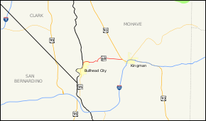
State Route 68, also known as SR 68, is an east–west highway in northwestern Arizona running from its western terminus at its junction with State Route 95 in Bullhead City to a grade-separated interchange at U.S. Route 93 northwest of Kingman. The western terminus formerly extended just to the west of its current point to Davis Dam; this became Mohave County Road 68 in 1998.
Route description
The primary purpose of this route is to carry traffic to Bullhead City and Laughlin, Nevada. Since September 11, 2001, the highway had also composed part of the mandatory detour for trucks and recreational vehicles traveling between Arizona and Las Vegas, Nevada via US 93, due to the heavy vehicle restrictions over Hoover Dam. The detour was temporary and was removed in 2010, when the new bypass was completed south of the dam .
History
SR 68 was a 2 lane highway and had a high grade going through the Black Mountains. The highway was expanded to 4 lanes in the mid-1990s and now has a smoother ride through the mountains.
Junction list
The entire route is in Mohave County.
| Location | mi[1] | km | Destinations | Notes | |
|---|---|---|---|---|---|
| Bullhead City | 0.00 | 0.00 | Western terminus; Bullhead Pkwy. serves Laughlin/Bullhead International Airport | ||
| Golden Valley | 27.88 | 44.87 | Interchange; eastern terminus; former US 466; US 93 exit 67 | ||
| 1.000 mi = 1.609 km; 1.000 km = 0.621 mi | |||||
References
- 1 2 Arizona Department of Transportation. "2008 ADOT Highway Log" (PDF). Retrieved April 18, 2008.
External links
Route map: