Texas State Highway 66
| ||||
|---|---|---|---|---|
 | ||||
| Route information | ||||
| Maintained by TxDOT | ||||
| Length | 35.0 mi[1] (56.3 km) | |||
| Existed | by 1933–present | |||
| Major junctions | ||||
| West end |
| |||
| East end |
| |||
| Location | ||||
| Counties | Dallas, Rockwall, Collin, Hunt | |||
| Highway system | ||||
| ||||

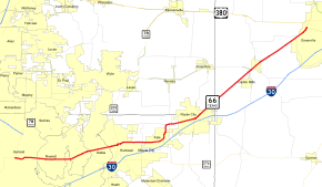
State Highway 66 or SH 66 is a state highway running from Garland to Greenville, roughly parallel to Interstate 30. Along the way, it passes through Rowlett, Rockwall, Fate, Royse City, and Caddo Mills. It also twice crosses Lake Ray Hubbard.
History

SH 66 was previously designated first on August 21, 1923 as a route from Bogata northeast through Clarksville toward the Oklahoma town of Idabel, replacing part of SH 37.[2] On June 24, 1931, this route had been added as a northern extent of SH 37, and was instead assigned along an ambitious route spanning the entire state from Wichita Falls to Pharr, replacing part of SH 25, part of SH 24, part of SH 108, all of SH 145, and part of SH 12.[3] On November 30, 1932, it extended south to the Rio Grande near Hidalgo, replacing part of SH 4, which was rerouted west.[4] On October 17, 1933, it extended to Oklahoma following SH 79.[5] On July 15, 1935, everything north of Wichita Falls was cancelled and the section from the Brazos River to Stephenville was cancelled. [6] On November 5, 1935, the section from Stephenville north to the Brazos River was restored.[7] On September 26, 1939, this entire second route was cancelled in favor of U.S. Highway 281, with one section from US 281 to the Hidalgo International Bridge becoming a spur of US 281, but Spur 241 in 1961.
The current route was designated on November 30, 1961, replacing FM 7 and U.S. Highway 67, which was rerouted atop I-30.
Junctions
| County | Location | mi | km | Destinations | Notes |
|---|---|---|---|---|---|
| Dallas | Garland | 0.000 | 0.000 | ||
| Rowlett | 4.4 | 7.1 | |||
| Rockwall | Rockwall | 10.3 | 16.6 | ||
| 11.5 | 18.5 | ||||
| 13.0 | 20.9 | ||||
| Fate | 15.1 | 24.3 | |||
| | 18.1 | 29.1 | |||
| | 18.3 | 29.5 | |||
| Royse City | 19.6 | 31.5 | |||
| Collin | 20.5 | 33.0 | |||
| Hunt | | 22.8 | 36.7 | ||
| Caddo Mills | 27.3 | 43.9 | |||
| 27.6 | 44.4 | ||||
| 28.2 | 45.4 | Southern end of FM 36 concurrency | |||
| 28.3 | 45.5 | Northern end of FM 36 concurrency | |||
| | 33.2 | 53.4 | |||
| | 33.6 | 54.1 | |||
| Greenville | 35.0 | 56.3 | |||
| 1.000 mi = 1.609 km; 1.000 km = 0.621 mi | |||||
References
- ↑ Texas Department of Transportation,
- ↑ (PDF) https://publicdocs.txdot.gov/minord/MinuteOrderDocLib/003676878.pdf. Missing or empty
|title=(help) - ↑ (PDF) https://publicdocs.txdot.gov/minord/MinuteOrderDocLib/003673804.pdf. Missing or empty
|title=(help) - ↑ (PDF) https://publicdocs.txdot.gov/minord/MinuteOrderDocLib/003673821.pdf. Missing or empty
|title=(help) - ↑ (PDF) https://publicdocs.txdot.gov/minord/MinuteOrderDocLib/003673837.pdf. Missing or empty
|title=(help) - ↑ (PDF) https://publicdocs.txdot.gov/minord/MinuteOrderDocLib/003673871.pdf. Missing or empty
|title=(help) - ↑ (PDF) https://publicdocs.txdot.gov/minord/MinuteOrderDocLib/003673877.pdf. Missing or empty
|title=(help)