Stari Petlykivtsi
| Stari Petlykivtsi Старі Петликівці | |
|---|---|
| Coordinates: 49°08′00″N 25°22′21″E / 49.13333°N 25.37250°ECoordinates: 49°08′00″N 25°22′21″E / 49.13333°N 25.37250°E | |
| Country |
|
| Oblast |
|
| Raion | Buchach Raion |
| Area | |
| • Total | 3.327 km2 (1.285 sq mi) |
| Population (2001 census) | |
| • Total | 1 024 |
| • Density | 307.78/km2 (797.1/sq mi) |
| Time zone | UTC+2 (EET) |
| • Summer (DST) | UTC+3 (EEST) |
| Postal code | 48413 |
| Area code(s) | +380 3544 |
Stari Petlykivtsi (Ukrainian: Старі Петликівці) is a village in the Buchach Raion (district) of the Ternopil Oblast (province) in western Ukraine. 1065 inhabitants lived in the village on 2007.
History
First written mention comes from the 15th century. Then belonged to the Polish-Lithuanian Commonwealth, from 1772 until 1918 to Austrian (Habsburg Monarchy, Austrian Empire, Austria-Hungary) empires, in 1918-1919 to West Ukrainian People's Republic. From 1991 belonged to Ukraine.
Reading room of Ukrainian society Prosvita operated in the village.
Attractions
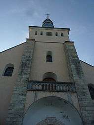
- Church of St. Dmytro (1875, reconstr. 1991)
- Chapel with statue of Holy Virgin Mary
- Roman Cath. Church
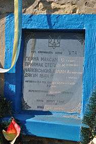
- Symbolic grave in place re disposal of warriors of Ukrainian Insurgent Army (1996)
Notable Persons
References
Sources
- (in Ukrainian) М. Бігус, В. Уніят, Старі Петликівці // Ternopil Encyclopedic Dictionary: in 4 v. / editorial board: H. Yavorskyi and other, Ternopil: "Zbruch", 2008, V. 3: П—Я, S. 334-335. — ISBN 978-966-528-279-2.
- (in Polish) Petlikowce in the Geographical Dictionary of the Kingdom of Poland, volume VIII (Perepiatycha — Pożajście) 1887, S. 24. (in Polish)
External links
| Wikimedia Commons has media related to Stari Petlykivtsi. |
| Cities | ||
|---|---|---|
| Urban-type settlements | ||
| Villages |
| |
This article is issued from
Wikipedia.
The text is licensed under Creative Commons - Attribution - Sharealike.
Additional terms may apply for the media files.