Standish, Greater Manchester
| Standish | |
|---|---|
 St Wilfred's Church from the Market Place | |
 Standish Standish shown within Greater Manchester | |
| OS grid reference | SD560102 |
| Metropolitan borough | |
| Metropolitan county | |
| Region | |
| Country | England |
| Sovereign state | United Kingdom |
| Post town | WIGAN |
| Postcode district | WN6 |
| Dialling code | 01257 |
| Police | Greater Manchester |
| Fire | Greater Manchester |
| Ambulance | North West |
| EU Parliament | North West England |
| UK Parliament | |
Standish is a large village in the Metropolitan Borough of Wigan, Greater Manchester, England.[1] Historically in Lancashire, it is on the A49 road between Chorley and Wigan, near Junction 27 of the M6 motorway.
Formed around a crossroads, the village has grown as urban expansion between Manchester and Liverpool extends outwards. The Church of St Wilfrid is a Grade I listed parish church.
History
The name Standish is derived from the Old English stan, meaning stone, and edisc, a park or enclosure.[2] It has been variously recorded as Stanedis in 1206, Stanediss in 1219, Standissh, Stanedich and Stanedissh in 1292 and Standisch in 1330. The adjoining village of Langtree was recorded as Langetre in 1206 and Longetre in 1330.[3] A Roman road passed through the township.[4]
Standish and Langtree were part of the Penwortham barony in the 12th century and between 1150 and 1164, Richard Bussel, Lord of Penwortham gave them to his brother-in-law Richard Spileman. In 1212 Thurstan Banastre held them and later they were held by William de Ferrers Earl of Derby, and then by 'the lords of Leylandshire'. The tenants adopted the local surnames, Standish and Langtree.[3]
In 1896 the Wigan Coal and Iron Company owned the Broomfield, Giant's Hall, Gidlow, John, Langtree, Robin Hill, Swire and Taylor Pits. The largest of these was the Langtree Pit with over 540 employees.[5]
Standish railway station was on the West Coast Main Line, but it closed in May 1949. Victoria Colliery has closed and has become a housing estate.
Governance
Lying within the historic county boundaries of Lancashire since the early 12th century, Standish emerged as a township in the Middle Ages but by the mid-19th century was united with neighbouring Langtree, as Standish-with-Langtree. The township was in the larger Standish ecclesiastical parish.
Following the Poor Law Amendment Act 1834, Standish-with-Langtree formed part of the Wigan Poor Law Union, an inter-parish unit established to administer the Poor Law which made use of premisess on Frog Lane Wigan and Hindley.[1][6] Standish-with-Langtree became a local board of health established in 1872; Standish-with-Langtree Local Board of Health was a regulatory body responsible for standards of hygiene and sanitation in the township.[1] Following the Local Government Act 1894, the area of the local board became an urban district within the administrative county of Lancashire.[1]
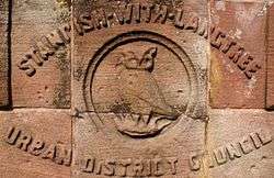
Under the Local Government Act 1972, the Standish-with-Langtree Urban District was abolished, and Standish has, since 1 April 1974, formed an unparished area of the Metropolitan Borough of Wigan, a local government district of the metropolitan county of Greater Manchester.[1][7] For electoral purposes, the village is within the Standish With Langtree Ward.
In May 2015, Standish Voice,[8] a residents' group formed in July 2014, was designated as the Neighbourhood Forum for Standish, with the aim of creating a Neighbourhood Plan[9] for the village. As part of their commitment to the community, Standish Voice organised the first ever Christmas market to be held in the village,[10] which took place on 3 December 2016.
Geography
Standish lies to the south and Langtree to north of the area, Standish covering 1,696 acres, and Langtree which had two separated portions, 1,568 acres, a total of 3,264 acres. The River Douglas and Bradley Brook form the boundary on the eastern side, the Mill Brook which flows into the Douglas forms the western boundary. Standish is situated on a ridge of high land which rises to 370 feet and runs north to south across the township, near the river the land is between 120 and 160 feet. The underlying rocks are the coal measures of the Lancashire Coalfield.[3][4]
Landmarks
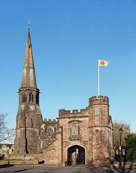
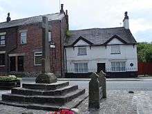
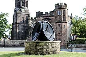
St Wilfrid's Parish Church is the only building with a Grade I listing in the Metropolitan Borough of Wigan.[11] In the Market Place in front of the church is a late medieval cross, stone stocks and a 14th-century well.
See also
References
- 1 2 3 4 5 "Greater Manchester Gazetteer". Greater Manchester County Record Office. Places names – S. Archived from the original on 18 July 2011. Retrieved 17 June 2008.
- ↑ Ekwall, Eilert (1972) [1922]. The Place-Names of Lancashire. Wakefield: EP Publishing. p. 127.
- 1 2 3 William Farrer; J Brownbill, eds. (1911), "Standish with Langtree", A History of the County of Lancaster: Volume6, Victoria County History, British History Online, pp. 192–199, retrieved 28 November 2010
- 1 2 Lewis, Samuel, ed. (1848), "Standish (St Wilfred)", A Topographical Dictionary of England, British History Online, pp. 180–183, retrieved 28 November 2010
- ↑ Wigan Coal & Iron Co. Ltd., Durham Mining Museum, retrieved 7 February 2011
- ↑ Workhouse, Workhouses.org, archived from the original on 5 June 2011, retrieved 28 November 2010
- ↑ HMSO. Local Government Act 1972. 1972 c.70.
- ↑ Standish Voice
- ↑ "Standish Neighbourhood Plan". www.wigan.gov.uk. Retrieved 2016-12-16.
- ↑ "Christmas Market - Standish Voice". Standish Voice. Retrieved 2016-12-16.
- ↑ "Listed Buildings in Wigan Borough" (PDF). Archived from the original (PDF) on 27 March 2009. Retrieved 15 December 2007.
External links
| Wikimedia Commons has media related to Standish, Greater Manchester. |