Interstate 405 (Oregon)
| ||||
|---|---|---|---|---|
|
I-405 highlighted in red | ||||
| Route information | ||||
| Maintained by ODOT | ||||
| Length | 4.25 mi[1] (6.84 km) | |||
| Existed | 1950s – present | |||
| Major junctions | ||||
| South end |
| |||
|
| ||||
| North end |
| |||
| Highway system | ||||
| ||||

Interstate 405 (I-405, also known as the Stadium Freeway No. 61[2]) is a short Interstate Highway in Portland, Oregon. It forms a loop from Interstate 5 that travels through downtown Portland west of the Willamette River.
Route description
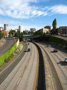
Interstate 405's southern terminus is at a complex Y-like stack interchange with Interstate 5 and Harbor Dr. (formerly Harbor Freeway) in the South Portland neighborhood, near the southern edge of downtown. The highway travels northwest for about a mile, passing the campus of Portland State University, to an interchange with the U.S. Route 26 freeway bound for the western suburbs of Portland. I-405 then travels north for just over a mile, forming the western edge of Downtown Portland. It runs mostly below grade through this area. At the north edge of downtown, as it approaches the Willamette River, I-405 reaches a Y interchange with U.S. Route 30. This interchange and the short freeway portion of U.S. 30 to which it connects were originally intended for the canceled I-505.
I-405 and U.S. 30 share alignment as they cross the Willamette River on the double-decker Fremont Bridge. At the northeastern end of the bridge is a partially completed stack interchange with Interstate 5; the canceled Rose City Freeway was to be a continuation of I-405, serving Portland International Airport and northeast Portland. Only a small stub portion of the Rose City Freeway was built, in order to provide a connection between the bridge and nearby Legacy Emanuel Hospital.
History
The earliest portion of Interstate 405 opened to traffic on February 25, 1969. The loop was completed in 1973 when the Fremont Bridge opened, linking I-405 to I-5 in North Portland. In August 2009 the entire route with the exception of the Fremont bridge was completely repaved for the first time after it opened to traffic. The bridge itself was repaved in August 2011.
In 1998, Mayor Vera Katz proposed capping a portion of the freeway in Downtown Portland with buildings and parks.[3]
Exit list
The entire route is in Portland, Multnomah County.
| mi[1] | km | Exit | Destinations | Notes | |
|---|---|---|---|---|---|
| −0.04 | −0.064 | — | Exit 299B on I-5 | ||
| 0.52 | 0.84 | 1A | South Waterfront – City Center | Northbound exit and southbound entrance | |
| 0.52 | 0.84 | — | Southbound exit and northbound entrance | ||
| 0.89 | 1.43 | 1B | 4th Avenue | Northbound exit and southbound entrance | |
| 1.03 | 1.66 | 1C | South end of US 26 concurrency | ||
| 1.40 | 2.25 | 1D | 12th Avenue | Northbound exit and southbound entrance | |
| 1.62 | 2.61 | North end of US 26 concurrency | |||
| 1.92 | 3.09 | 2A | Salmon Street – Providence Park | Northbound exit and southbound entrance | |
| 2.20 | 3.54 | Burnside Street / Couch Street | Southbound exit and northbound entrance | ||
| 2.35 | 3.78 | 2B | Everett Street | ||
| 3.08 | 4.96 | 3 | South end of US 30 concurrency | ||
| 3.78 | 6.08 | — | North end of US 30 concurrency; northbound exit and southbound entrance | ||
| 4.18 | 6.73 | — | Kerby Avenue | Northbound exit and southbound entrance | |
| 4.21 | 6.78 | — | Exit 302B on I-5 | ||
1.000 mi = 1.609 km; 1.000 km = 0.621 mi
| |||||
References
- 1 2 Oregon Department of Transportation, Public Road Inventory Archived 2008-02-24 at the Wayback Machine. (primarily the Digital Video Log), accessed April 2008
- ↑ "Trans Dev - Transportation Data Routes | State Highway Cross Reference". Oregon Department of Transportation. 4 February 2007. Retrieved 21 February 2010.
- ↑ Mehlhaf, Nina (February 25, 2015). "Grassroots support for building I-405 freeway cap". KGW. Retrieved 16 August 2015.
External links
Route map:
![]()